1960s Maps of Morehouse Parish, Louisiana
Explore 7 historic maps of Morehouse Parish from the 1960s. These maps offer a rare glimpse into what life looked like during the 1960s — showing old roads, neighborhoods, homes, and landmarks that have changed or disappeared over time.
Whether you're researching your family's past, planning a metal detecting trip, or studying how Morehouse Parish's landscape evolved across the 1960s, these high-resolution maps are a powerful tool for exploring the history of this region.
- Focus on a specific era: All maps on this page are from the 1960s, giving you a focused view of this time period.
- See what’s changed: Compare century-old streets, trails, and buildings to today's modern landscape using overlays and satellite layers.
- Research with precision: Use these maps for genealogy, historical research, land use analysis, or educational projects.
- View, download, or print: Maps are fully viewable online in high resolution, and can be downloaded or printed for your own records.
Start exploring Morehouse Parish's history through authentic maps from the 1960s. This is your window into the past.
Morehouse Parish, LA maps
(7)- 1960 Map of El Dorado
 1960 El Dorado1960 Print · USGSSouth Central Arkansas in the late fifties was a hub of energy production and defense industry. Researchers can trace the extensive Oil and Gas Fields around El Dorado or locate family landmarks like Old Park Cem and New Hope Church.
 - 1960 Map of Wilmot, 1961 Print
 1960 Wilmot1961 Print · USGSThe borderlands of southeast Arkansas and northeast Louisiana are defined by the winding oxbows of Bayou Bartholomew and the Missouri Pacific railroad. Genealogists can trace early rural life through landmarks like Chiller Chapel Cem, Savage High Sch, and the town of Wilmot.2 unique versions available
 - 1960 Map of Wilmot, 1961 Print
 1960 Wilmot1961 Print · USGSThe Arkansas delta near the Louisiana border is captured here in the early sixties, centered on the river-and-rail corridor of the Missouri Pacific. Researchers can trace rural life through sites like Savage High Sch, Wilmot Cem, and the winding Bayou Bartholomew.3 unique versions available
 - 1960 Map of Wilmot SW, 1961 Print
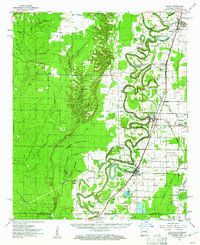
 1960 Wilmot SW1961 Print · USGSThe Arkansas-Louisiana borderlands come alive in the early sixties as a network of brakes and bayous. Researchers can locate remote family burial sites like Poley Bridge Cem and historic congregational centers such as St Matthew Ch near Bayou Bartholomew.2 unique versions available
 - 1961 Map of Jackson
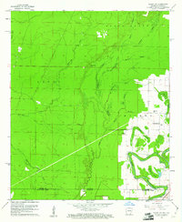
 1961 Jackson1961 Print · USGSThe Lower Mississippi Delta and the state capital area are captured here during the post-war era of infrastructure expansion. Researchers can trace the complex river oxbows and rail lines connecting Vicksburg, Yazoo City, and the Illinois Central Railroad network.
 - 1962 Map of Jackson
 1962 Jackson1962 Print · USGSThe Mississippi Delta and the state capital region are mapped here in the early sixties, showing a landscape defined by the great river and the growing city of JACKSON. Genealogists can trace family roots through numerous landmarks like Cedar Hill Cem, rural stops on the Illinois Central RR, and historic sites like Champion Hill.2 unique versions available
 - 1969 Map of Monroe North
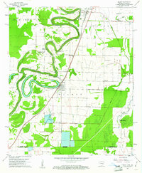
 1969 Monroe North1969 Print · USGSMonroe and West Monroe enter a period of rapid growth during the late sixties as urban development pushes into the surrounding bayous. Genealogists can trace family names and local sites from Northeast Louisiana State College to the quiet grounds of Memorial Park Cem and rural Ouachita City.
End of results
Showing maps 1-7 of 7
Top cities of Morehouse Parish
- Bastrop historical maps
- Mer Rouge historical maps
- Bonita historical maps
- Collinston historical maps
- Oak Ridge historical maps
Frequently asked questions
- What are the different types of historical maps available for Morehouse Parish?
- What is the oldest map of Morehouse Parish?
- Where can I purchase historical maps of Morehouse Parish for my home or office?
- Where can I download high-res historical maps of Morehouse Parish?
- Are there historical topographic maps available for Morehouse Parish?
- Is there historical aerial imagery available for Morehouse Parish?
- Where are historical maps of Morehouse Parish sourced from?