1940s Maps of Nestor, Louisiana
Explore 2 historic maps of Nestor from the 1940s. These maps offer a rare glimpse into what life looked like during the 1940s — showing old roads, neighborhoods, homes, and landmarks that have changed or disappeared over time.
Whether you're researching your family's past, planning a metal detecting trip, or studying how Nestor's landscape evolved across the 1940s, these high-resolution maps are a powerful tool for exploring the history of this region.
- Focus on a specific era: All maps on this page are from the 1940s, giving you a focused view of this time period.
- See what’s changed: Compare century-old streets, trails, and buildings to today's modern landscape using overlays and satellite layers.
- Research with precision: Use these maps for genealogy, historical research, land use analysis, or educational projects.
- View, download, or print: Maps are fully viewable online in high resolution, and can be downloaded or printed for your own records.
Start exploring Nestor's history through authentic maps from the 1940s. This is your window into the past.
Nestor, LA maps
(2)- 1941 Map of Empire
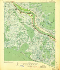 1941 Empire1941 Print · USGSPlaquemines Parish comes to life in this pre-war survey of the Mississippi River delta as it transitions into the Gulf. Genealogists and historians can trace the riverfront rail line through Port Sulphur and Buras, or locate landmarks like Pt Pleasant Cem and Swartze Sch.
 - 1944 Map of Empire
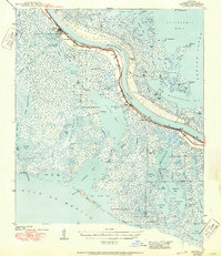 1944 Empire1944 Print · USGSThe Mississippi River delta in the 1940s reveals a fragile line of settlement between the river and the Gulf. Researchers can trace the layout of Port Sulphur, locate the Ft Pleasant Cem, and follow the old Ferry to Pt. a la Hache.2 unique versions available
End of results
Showing maps 1-2 of 2
Top cities near Nestor
Frequently asked questions
- What are the different types of historical maps available for Nestor?
- What is the oldest map of Nestor?
- Where can I purchase historical maps of Nestor for my home or office?
- Where can I download high-res historical maps of Nestor?
- Are there historical topographic maps available for Nestor?
- Is there historical aerial imagery available for Nestor?
- Where are historical maps of Nestor sourced from?