1950s Maps of Pilottown, Louisiana
Explore 3 historic maps of Pilottown from the 1950s. These maps offer a rare glimpse into what life looked like during the 1950s — showing old roads, neighborhoods, homes, and landmarks that have changed or disappeared over time.
Whether you're researching your family's past, planning a metal detecting trip, or studying how Pilottown's landscape evolved across the 1950s, these high-resolution maps are a powerful tool for exploring the history of this region.
- Focus on a specific era: All maps on this page are from the 1950s, giving you a focused view of this time period.
- See what’s changed: Compare century-old streets, trails, and buildings to today's modern landscape using overlays and satellite layers.
- Research with precision: Use these maps for genealogy, historical research, land use analysis, or educational projects.
- View, download, or print: Maps are fully viewable online in high resolution, and can be downloaded or printed for your own records.
Start exploring Pilottown's history through authentic maps from the 1950s. This is your window into the past.
Pilottown, LA maps
(3)- 1953 Map of West Delta
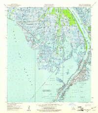
 1953 West Delta1953 Print · USGSThe lower reaches of the Mississippi Delta come alive in this mid-century survey of the river's final descent into the Gulf. Maritime researchers and genealogists can trace the remote outpost of Pilottown, the Old Quarantine Sta, and family-named wetlands like Bob Taylors Pond.
 - 1957 Map of Breton Sound, 1967 Print
 1957 Breton Sound1967 Print · USGSThe Mississippi River delta is captured here in the mid-fifties, showing the fragile marshlands and river-dependent towns of the Louisiana coast. Genealogists and historians can trace riverside settlements like Pointe a la Hache, Pilottown, and Port Sulphur.3 unique versions available
 - 1958 Map of West Delta, 1961 Print
 1958 West Delta1961 Print · USGSThe Mississippi Delta's final reaches are captured here in the late fifties as the river meets the Gulf. Genealogists and historians can trace the river-life hub at Pilottown and the maritime infrastructure of the Old Quarantine Station and Head of Passes.2 unique versions available
End of results
Showing maps 1-3 of 3
Top cities near Pilottown
Frequently asked questions
- What are the different types of historical maps available for Pilottown?
- What is the oldest map of Pilottown?
- Where can I purchase historical maps of Pilottown for my home or office?
- Where can I download high-res historical maps of Pilottown?
- Are there historical topographic maps available for Pilottown?
- Is there historical aerial imagery available for Pilottown?
- Where are historical maps of Pilottown sourced from?