1950s Maps of Valverda, Louisiana
Explore 5 historic maps of Valverda from the 1950s. These maps offer a rare glimpse into what life looked like during the 1950s — showing old roads, neighborhoods, homes, and landmarks that have changed or disappeared over time.
Whether you're researching your family's past, planning a metal detecting trip, or studying how Valverda's landscape evolved across the 1950s, these high-resolution maps are a powerful tool for exploring the history of this region.
- Focus on a specific era: All maps on this page are from the 1950s, giving you a focused view of this time period.
- See what’s changed: Compare century-old streets, trails, and buildings to today's modern landscape using overlays and satellite layers.
- Research with precision: Use these maps for genealogy, historical research, land use analysis, or educational projects.
- View, download, or print: Maps are fully viewable online in high resolution, and can be downloaded or printed for your own records.
Start exploring Valverda's history through authentic maps from the 1950s. This is your window into the past.
Valverda, LA maps
(5)- 1954 Map of Fordoche, 1955 Print
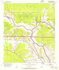 1954 Fordoche1955 Print · USGSMid-century Pointe Coupee Parish reveals a landscape defined by the intersection of the Missouri Pacific railroad and winding bayous. Genealogists and historians can locate family landmarks like Bailey Cem, Sunlight Ch, and the petroleum operations at Lottie Oil Field.2 unique versions available
 - 1954 Map of Baton Rouge, 1974 Print
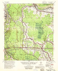
 1954 Baton Rouge1974 Print · USGSSoutheast Louisiana in the mid-fifties is captured here during a period of transition for its river and rail economies. Researchers can trace the path of the Mississippi River and find landmarks like the Bonnet Carre Spillway and Bayou Plaquemine.2 unique versions available
 - 1955 Map of Fordoche
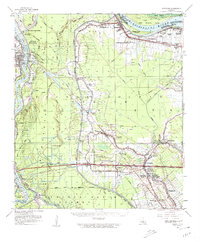
 1955 Fordoche1955 Print · USGSMid-century Pointe Coupee Parish reveals a landscape of massive flood control projects and active bayou life during the 1950s. Genealogists and researchers can locate family landmarks like Argyle Plantation or the Zion Traveler Ch & Cem and trace the early development of the Fordoche Oil Field.
 - 1956 Map of Baton Rouge
 1956 Baton Rouge1956 Print · USGSSouth Louisiana at the height of the mid-century oil boom shows a landscape of river oxbows and rising industry. Researchers can trace family roots through river towns like Scotlandville or locate early industrial sites and Oil wells near Lake Maurepas.
 - 1959 Map of Fordoche, 1962 Print
 1959 Fordoche1962 Print · USGSLouisiana's river country is captured here in the late fifties, as the oil industry began to shape the landscape of Pointe Coupee Parish. Genealogists can locate family landmarks like Cottonwood Cem., Argyle Plantation, and the Sunlight Ch. near Blanks.2 unique versions available
End of results
Showing maps 1-5 of 5
Top cities near Valverda
- New Roads historical maps
- Melville historical maps
- Krotz Springs historical maps
- Livonia historical maps
- Fordoche historical maps
- Maringouin historical maps
See more
Frequently asked questions
- What are the different types of historical maps available for Valverda?
- What is the oldest map of Valverda?
- Where can I purchase historical maps of Valverda for my home or office?
- Where can I download high-res historical maps of Valverda?
- Are there historical topographic maps available for Valverda?
- Is there historical aerial imagery available for Valverda?
- Where are historical maps of Valverda sourced from?