1940s Maps of East Point, Louisiana
Explore 2 historic maps of East Point from the 1940s. These maps offer a rare glimpse into what life looked like during the 1940s — showing old roads, neighborhoods, homes, and landmarks that have changed or disappeared over time.
Whether you're researching your family's past, planning a metal detecting trip, or studying how East Point's landscape evolved across the 1940s, these high-resolution maps are a powerful tool for exploring the history of this region.
- Focus on a specific era: All maps on this page are from the 1940s, giving you a focused view of this time period.
- See what’s changed: Compare century-old streets, trails, and buildings to today's modern landscape using overlays and satellite layers.
- Research with precision: Use these maps for genealogy, historical research, land use analysis, or educational projects.
- View, download, or print: Maps are fully viewable online in high resolution, and can be downloaded or printed for your own records.
Start exploring East Point's history through authentic maps from the 1940s. This is your window into the past.
East Point, LA maps
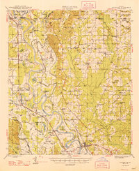
(2)- 1941 Map of East Point
 1941 East Point1941 Print · USGSThe Red River Valley bottomlands are captured here in the late 1930s, showing a network of riverfront settlements and rural parish life. Researchers can trace family history through numerous landmarks like Elizabeth Church, Crichton School, and the St Marks Cemetery near the Bayou Toulon.
 - 1948 Map of Coushatta
 1948 Coushatta1948 Print · USGSRed River Parish and the surrounding hill country are captured here just after the war, showing the intricate river-and-rail network. Genealogists can trace family names through dozens of landmarks like Elizabeth Sch, St Pauls Cem, and Hall Summit.
End of results
Showing maps 1-2 of 2
Top cities near East Point
- Coushatta historical maps
- Ringgold historical maps
- Martin historical maps
- Hall Summit historical maps
- Edgefield historical maps
- Jamestown historical maps
Frequently asked questions
- What are the different types of historical maps available for East Point?
- What is the oldest map of East Point?
- Where can I purchase historical maps of East Point for my home or office?
- Where can I download high-res historical maps of East Point?
- Are there historical topographic maps available for East Point?
- Is there historical aerial imagery available for East Point?
- Where are historical maps of East Point sourced from?