1930s Maps of Delhi, Louisiana
Explore 2 historic maps of Delhi from the 1930s. These maps offer a rare glimpse into what life looked like during the 1930s — showing old roads, neighborhoods, homes, and landmarks that have changed or disappeared over time.
Whether you're researching your family's past, planning a metal detecting trip, or studying how Delhi's landscape evolved across the 1930s, these high-resolution maps are a powerful tool for exploring the history of this region.
- Focus on a specific era: All maps on this page are from the 1930s, giving you a focused view of this time period.
- See what’s changed: Compare century-old streets, trails, and buildings to today's modern landscape using overlays and satellite layers.
- Research with precision: Use these maps for genealogy, historical research, land use analysis, or educational projects.
- View, download, or print: Maps are fully viewable online in high resolution, and can be downloaded or printed for your own records.
Start exploring Delhi's history through authentic maps from the 1930s. This is your window into the past.
Delhi, LA maps
(2)- 1935 Map of Baskinton, 1936 Print
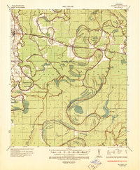
 1935 Baskinton1936 Print · USGSNortheast Louisiana in the mid-1930s is defined by its drainage basins and river landings between the rail towns of Rayville and Delhi. Genealogists can locate rural landmarks such as Hill Ridge Ch & Sch, Baskinton, and landings like Sunrise Ldg.
 - 1935 Map of Waverly, 1938 Print
 1935 Waverly1938 Print · USGSThe Louisiana delta in the mid-1930s shows a landscape defined by the winding Tensas River and early industrial expansion. Trace the remnants of a Logging Railroad Abandoned and the growth of trackside settlements like Delhi and Quebec.2 unique versions available
End of results
Showing maps 1-2 of 2
Top cities near Delhi
Frequently asked questions
- What are the different types of historical maps available for Delhi?
- What is the oldest map of Delhi?
- Where can I purchase historical maps of Delhi for my home or office?
- Where can I download high-res historical maps of Delhi?
- Are there historical topographic maps available for Delhi?
- Is there historical aerial imagery available for Delhi?
- Where are historical maps of Delhi sourced from?