
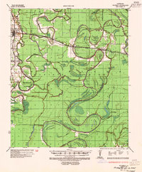
1935 Map of Waverly
USGS Topo · Published 1938About this map
The Tensas River and its complex network of oxbow lakes and bayous dominate this mid-1930s landscape across Madison Parish, Franklin Parish, and Richland Parish. Settled nodes like Delhi, Waverly, and Quebec line the Illinois Central railroad corridor, while the backswamps are marked by numerous water bodies including Eagle Lake, Africa Lake, and Lost Lake. A notable industrial detail is the abandoned logging railroad snaking through the northern section, a testament to the era's timber extraction before the land was fully converted to agriculture.
Find a feature on this map
48 named features on this map. Tap any name to fly to it.
Don’t see what you’re looking for? This feature index may not catch every label — zoom into the map to look around manually.
Map Details
Editions of this 1935 Waverly Map
2 editions found
Other maps of this area

1909 · Tallulah
USGS Topo · 1:24,000

1935 · Winnsboro
USGS Topo · 1:62,500

1935 · Baskinton
USGS Topo · 1:62,500

1935 · Hurricane
USGS Topo · 1:62,500

1935 · Shackleford Lake
USGS Topo · 1:62,500

1939 · Talla Bena
USGS Topo · 1:62,500

1939 · Alsatia
USGS Topo · 1:62,500

1955 · Jackson
USGS Topo · 1:250,000

1958 · Baskinton
USGS Topo · 1:62,500

1958 · Hurricane
USGS Topo · 1:62,500