1980s Maps of Many, Louisiana
Explore 3 historic maps of Many from the 1980s. These maps offer a rare glimpse into what life looked like during the 1980s — showing old roads, neighborhoods, homes, and landmarks that have changed or disappeared over time.
Whether you're researching your family's past, planning a metal detecting trip, or studying how Many's landscape evolved across the 1980s, these high-resolution maps are a powerful tool for exploring the history of this region.
- Focus on a specific era: All maps on this page are from the 1980s, giving you a focused view of this time period.
- See what’s changed: Compare century-old streets, trails, and buildings to today's modern landscape using overlays and satellite layers.
- Research with precision: Use these maps for genealogy, historical research, land use analysis, or educational projects.
- View, download, or print: Maps are fully viewable online in high resolution, and can be downloaded or printed for your own records.
Start exploring Many's history through authentic maps from the 1980s. This is your window into the past.
Many, LA maps
(3)- 1986 Map of Natchitoches
 1986 Natchitoches1986 Print · USGSNorthwestern Louisiana during the mid-eighties shows a landscape shaped by major water projects and timberlands. Researchers can trace historic routes like the Old Spanish Trail or locate rural communities such as Fort Jesup, Fairview Alpha, and Grappes Bluff.2 unique versions available
 - 1988 Map of Loring
 1988 Loring1988 Print · USGSThe Sabine Parish shoreline and the upper reaches of the Toledo Bend Reservoir are captured here in the late eighties. Researchers can trace the settlement at Loring or locate a rural Cem near the banks of Harpoon Bayou.
 - 1988 Map of Many
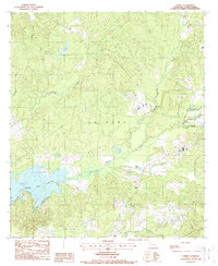
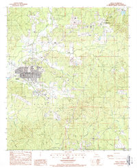 1988 Many1988 Print · USGSIn the late 1980s, the area around the Sabine Parish seat was a mix of municipal growth and deep-rooted frontier history. Genealogists and researchers can locate several rural Cem sites and trace the historic grounds of the Fort Jesup State Commemorative Area.
End of results
Showing maps 1-3 of 3
Top cities near Many
- Zwolle historical maps
- Florien historical maps
- Converse historical maps
- Fisher historical maps
- Noble historical maps
- Robeline historical maps
Top neighborhoods of Many
Frequently asked questions
- What are the different types of historical maps available for Many?
- What is the oldest map of Many?
- Where can I purchase historical maps of Many for my home or office?
- Where can I download high-res historical maps of Many?
- Are there historical topographic maps available for Many?
- Is there historical aerial imagery available for Many?
- Where are historical maps of Many sourced from?