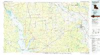
1986 Map of Natchitoches
USGS Topo · Published 1986About this map
Natchitoches serves as the focal point of this mid-1980s survey, where the Red River and Cane River Lake dominate the eastern landscape. The map reveals a complex web of waterways, from the sprawling Toledo Bend Reservoir on the western boundary with Texas to the many bayous like Bayou Pierre and Bayou Scie that thread through the parishes. Settlement patterns are defined by historic corridors, including the Old Spanish Trail and the routes of the Kansas City Southern and Texas and Pacific railroads. Significant public lands such as the Sabine National Forest and Kisatchie National Forest frame the rural communities of Pleasant Hill, Robeline, and Flora. This edition captures the region's geography after the creation of the reservoir, illustrating the dramatic change in the western shoreline along the Sabine River compared to earlier decades.
Find a feature on this map
83 named features on this map. Tap any name to fly to it.
Don’t see what you’re looking for? This feature index may not catch every label — zoom into the map to look around manually.
Map Details
Editions of this 1986 Natchitoches Map
2 editions found
Other maps of this area

1935 · Hagewood
USGS Topo · 1:31,680

1937 · Campti NE
USGS Topo · 1:31,680

1937 · Bermuda
USGS Topo · 1:31,680

1937 · Campti SE
USGS Topo · 1:31,680

1937 · Campti NW
USGS Topo · 1:31,680

1937 · Chopin NW
USGS Topo · 1:31,680

1937 · Bellwood
USGS Topo · 1:31,680

1937 · Montgomery
USGS Topo · 1:62,500

1937 · Campti SW
USGS Topo · 1:31,680

1937 · Cloutierville
USGS Topo · 1:31,680