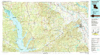
1986 Map of Natchitoches
USGS Topo · Published 1989About this map
The Toledo Bend Reservoir dominates the western landscape of this mid-1980s survey, marking a massive aquatic border between Louisiana and Texas. To the east, the historic city of Natchitoches sits along the banks of Cane River Lake, reflecting centuries of river-based commerce and settlement. The geography is defined by the transition from the Sabine River valley to the timberlands of the Sabine National Forest and Kisatchie National Forest.
Find a feature on this map
104 named features on this map. Tap any name to fly to it.
Don’t see what you’re looking for? This feature index may not catch every label — zoom into the map to look around manually.
Map Details
Editions of this 1986 Natchitoches Map
2 editions found
Other maps of this area

1935 · Hagewood
USGS Topo · 1:31,680

1937 · Campti NE
USGS Topo · 1:31,680

1937 · Bermuda
USGS Topo · 1:31,680

1937 · Campti SE
USGS Topo · 1:31,680

1937 · Campti NW
USGS Topo · 1:31,680

1937 · Chopin NW
USGS Topo · 1:31,680

1937 · Bellwood
USGS Topo · 1:31,680

1937 · Montgomery
USGS Topo · 1:62,500

1937 · Campti SW
USGS Topo · 1:31,680

1937 · Cloutierville
USGS Topo · 1:31,680