1900s (20th Century) Maps of Jack, Louisiana
Explore 10 historic maps of Jack from the 1900s (20th Century). These maps offer a rare glimpse into what life looked like during the 1900s — showing old roads, neighborhoods, homes, and landmarks that have changed or disappeared over time.
Whether you're researching your family's past, planning a metal detecting trip, or studying how Jack's landscape evolved across the 1900s, these high-resolution maps are a powerful tool for exploring the history of this region.
- Focus on a specific era: All maps on this page are from the 1900s, giving you a focused view of this time period.
- See what’s changed: Compare century-old streets, trails, and buildings to today's modern landscape using overlays and satellite layers.
- Research with precision: Use these maps for genealogy, historical research, land use analysis, or educational projects.
- View, download, or print: Maps are fully viewable online in high resolution, and can be downloaded or printed for your own records.
Start exploring Jack's history through authentic maps from the 1900s. This is your window into the past.
Jack, LA maps
(10)- 1942 Map of Montpelier
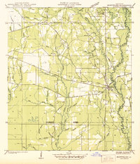 1942 Montpelier1942 Print · USGSThe village of Montpelier and the winding Tickfaw River are captured here during the early 1940s. Genealogists and local historians can trace parish lines and locate community landmarks like Shiloh Ch, Morgan Sch, and Hillsdale Cem.
 - 1954 Map of Montpelier
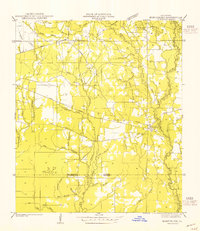 1954 Montpelier1954 Print · USGSThe rural landscape of St. Helena Parish is captured here in the mid-1950s, centered on the community of Montpelier. Genealogists and historians can trace local landmarks like Hillsdale Cem, the Old Railroad Grade, and several country schools including Mt Zion Sch.
 - 1954 Map of Baton Rouge, 1974 Print
 1954 Baton Rouge1974 Print · USGSSoutheast Louisiana in the mid-fifties is captured here during a period of transition for its river and rail economies. Researchers can trace the path of the Mississippi River and find landmarks like the Bonnet Carre Spillway and Bayou Plaquemine.2 unique versions available
 - 1956 Map of Baton Rouge
 1956 Baton Rouge1956 Print · USGSSouth Louisiana at the height of the mid-century oil boom shows a landscape of river oxbows and rising industry. Researchers can trace family roots through river towns like Scotlandville or locate early industrial sites and Oil wells near Lake Maurepas.
 - 1959 Map of Amite, 1960 Print
 1959 Amite1960 Print · USGSSoutheastern Louisiana parishes in the late fifties show a landscape of river-fed bottomlands and rail-centered towns. Genealogists can trace family lines at Leonard Chapel Cems, Gatlin Cem, and the St John the Baptist Chapel.3 unique versions available
 - 1961 Map of Baton Rouge, 1966 Print
 1961 Baton Rouge1966 Print · USGSSoutheastern Louisiana in the early sixties remains a landscape of deep river bends and sprawling coastal lakes. Genealogists and historians can trace the rail-and-river economy through landmarks like Free-Nigger Point, Donaldsonville, and the Illinois Central Railroad.
 - 1962 Map of Baton Rouge
 1962 Baton Rouge1962 Print · USGSSouth Louisiana in the early sixties reveals a landscape of river-bend parishes and emerging interstate corridors. Genealogists and historians can trace family roots through historic river towns like Donaldsonville and Plaquemine, or follow the path of the Illinois Central Railroad through the swamp basins.
 - 1974 Map of Montpelier, 1978 Print
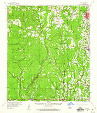
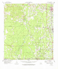
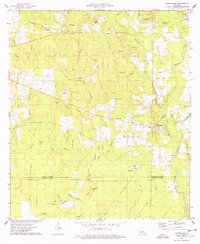 1974 Montpelier1978 Print · USGSSt. Helena Parish during the mid-seventies is mapped here at a time when the rural landscape was defined by small timber-and-creek communities. Researchers can trace family roots at Hillsdale Cem or locate old community centers like Midway Ch and Jack.
 - 1974 Map of Amite, 1978 Print
 1974 Amite1978 Print · USGSSoutheastern Louisiana’s parish boundaries and river bottoms come into focus in the mid-seventies. Genealogists can trace family names through rural landmarks like Sharkey Cem, Leonard Chapel, and the Illinois Central Gulf rail corridor.
 - 1983 Map of Amite
 1983 Amite1983 Print · USGSThe Florida Parishes and southern Mississippi are captured here in the early 1980s, centered on the Illinois Central Gulf rail corridor. Genealogists and historians can trace family-named sites like the Camp Moore Confederate Cem, Magnolia Ch, and the Idlewild Plantation (State University).
End of results
Showing maps 1-10 of 10
Top cities near Jack
- Hammond historical maps
- Kentwood historical maps
- Independence historical maps
- Roseland historical maps
- Tangipahoa historical maps
- Tickfaw historical maps
See more
Frequently asked questions
- What are the different types of historical maps available for Jack?
- What is the oldest map of Jack?
- Where can I purchase historical maps of Jack for my home or office?
- Where can I download high-res historical maps of Jack?
- Are there historical topographic maps available for Jack?
- Is there historical aerial imagery available for Jack?
- Where are historical maps of Jack sourced from?