1990s Maps of Breaux Bridge, Louisiana
Explore 2 historic maps of Breaux Bridge from the 1990s. These maps offer a rare glimpse into what life looked like during the 1990s — showing old roads, neighborhoods, homes, and landmarks that have changed or disappeared over time.
Whether you're researching your family's past, planning a metal detecting trip, or studying how Breaux Bridge's landscape evolved across the 1990s, these high-resolution maps are a powerful tool for exploring the history of this region.
- Focus on a specific era: All maps on this page are from the 1990s, giving you a focused view of this time period.
- See what’s changed: Compare century-old streets, trails, and buildings to today's modern landscape using overlays and satellite layers.
- Research with precision: Use these maps for genealogy, historical research, land use analysis, or educational projects.
- View, download, or print: Maps are fully viewable online in high resolution, and can be downloaded or printed for your own records.
Start exploring Breaux Bridge's history through authentic maps from the 1990s. This is your window into the past.
Breaux Bridge, LA maps
(2)- 1998 Map of Breaux Bridge, 2000 Print
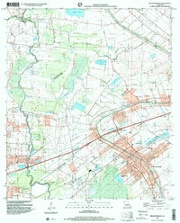 1998 Breaux Bridge2000 Print · USGSBreaux Bridge and the surrounding Cajun heartland appear in the late nineties as a landscape defined by its historic bayous and oil industry. Researchers can trace family sites at St Bernard Cem or explore the old transport routes of the Old Railroad Grade and Bayou Teche.
 - 1998 Map of Cecilia, 2003 Print
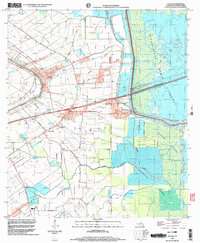 1998 Cecilia2003 Print · USGSSt. Martin Parish in the late nineties shows a landscape balanced between Bayou Teche settlement and the Atchafalaya basin. Researchers can locate family landmarks like Our Lady of Mercy Cem or trace the early foundations of Nina Station and Henderson.
End of results
Showing maps 1-2 of 2
Top cities near Breaux Bridge
- Lafayette historical maps
- Opelousas historical maps
- Scott historical maps
- Carencro historical maps
- Youngsville historical maps
- Sunset historical maps
See more
Frequently asked questions
- What are the different types of historical maps available for Breaux Bridge?
- What is the oldest map of Breaux Bridge?
- Where can I purchase historical maps of Breaux Bridge for my home or office?
- Where can I download high-res historical maps of Breaux Bridge?
- Are there historical topographic maps available for Breaux Bridge?
- Is there historical aerial imagery available for Breaux Bridge?
- Where are historical maps of Breaux Bridge sourced from?