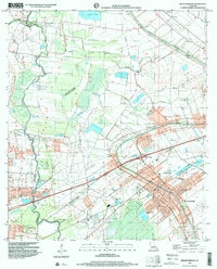
1998 Map of Breaux Bridge
USGS Topo · Published 2000About this map
Bayou Teche and the Vermilion River anchor this late 20th-century view of the Acadiana landscape, revealing a complex network of waterways including Bayou Pont Brule and Coulee Cocodrie. The settlement of Breaux Bridge serves as the primary hub, where the transition from traditional riverfront life to modern infrastructure is evident in the presence of Gary Memorial Hospital and various industrial sites. The map documents the persistent agricultural and extractive character of the region through the Anse La Butte Field and scattered oil wells.
Find a feature on this map
29 named features on this map. Tap any name to fly to it.
Don’t see what you’re looking for? This feature index may not catch every label — zoom into the map to look around manually.
Map Details
Editions of this 1998 Breaux Bridge Map
This is the sole edition of this map. No revisions or reprints were ever made.
Other maps of this area

1939 · St. Martinsville
USGS Topo · 1:62,500

1940 · Arnaudville
USGS Topo · 1:62,500

1946 · Lafayette
USGS Topo · 1:31,680

1952 · Lake Charles
USGS Topo · 1:250,000

1954 · Lafayette
USGS Topo · 1:31,680

1954 · Lake Charles
USGS Topo · 1:250,000

1954 · Baton Rouge
USGS Topo · 1:250,000

1955 · Lafayette
USGS Topo · 1:24,000
1955 · Lafayette
USGS Topo · 1:62,500

1956 · Baton Rouge
USGS Topo · 1:250,000