1990s Maps of Pelba, Louisiana
Explore 1 historic maps of Pelba from the 1990s. These maps offer a rare glimpse into what life looked like during the 1990s — showing old roads, neighborhoods, homes, and landmarks that have changed or disappeared over time.
Whether you're researching your family's past, planning a metal detecting trip, or studying how Pelba's landscape evolved across the 1990s, these high-resolution maps are a powerful tool for exploring the history of this region.
- Focus on a specific era: All maps on this page are from the 1990s, giving you a focused view of this time period.
- See what’s changed: Compare century-old streets, trails, and buildings to today's modern landscape using overlays and satellite layers.
- Research with precision: Use these maps for genealogy, historical research, land use analysis, or educational projects.
- View, download, or print: Maps are fully viewable online in high resolution, and can be downloaded or printed for your own records.
Start exploring Pelba's history through authentic maps from the 1990s. This is your window into the past.
Pelba, LA maps
(1)- 1999 Map of Butte La Rose, 2000 Print
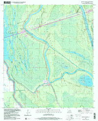 1999 Butte La Rose2000 Print · USGSThe Atchafalaya Basin in the late twentieth century remains a labyrinth of waterways and small landings. Researchers can trace the river's path past Butte La Rose, locate the Atchafalaya Radio Tower, or explore the secluded reaches of Cow Island Lake and Lost Lake.
End of results
Showing maps 1-1 of 1
Top cities near Pelba
- Breaux Bridge historical maps
- Youngsville historical maps
- Port Barre historical maps
- Henderson historical maps
- Krotz Springs historical maps
- Livonia historical maps
See more
Frequently asked questions
- What are the different types of historical maps available for Pelba?
- What is the oldest map of Pelba?
- Where can I purchase historical maps of Pelba for my home or office?
- Where can I download high-res historical maps of Pelba?
- Are there historical topographic maps available for Pelba?
- Is there historical aerial imagery available for Pelba?
- Where are historical maps of Pelba sourced from?