1900s (20th Century) Maps of St. John the Baptist Parish, Louisiana
Explore 67 historic maps of St. John the Baptist Parish from the 1900s (20th Century). These maps offer a rare glimpse into what life looked like during the 1900s — showing old roads, neighborhoods, homes, and landmarks that have changed or disappeared over time.
Whether you're researching your family's past, planning a metal detecting trip, or studying how St. John the Baptist Parish's landscape evolved across the 1900s, these high-resolution maps are a powerful tool for exploring the history of this region.
- Focus on a specific era: All maps on this page are from the 1900s, giving you a focused view of this time period.
- See what’s changed: Compare century-old streets, trails, and buildings to today's modern landscape using overlays and satellite layers.
- Research with precision: Use these maps for genealogy, historical research, land use analysis, or educational projects.
- View, download, or print: Maps are fully viewable online in high resolution, and can be downloaded or printed for your own records.
Start exploring St. John the Baptist Parish's history through authentic maps from the 1900s. This is your window into the past.
St. John the Baptist Parish, LA maps
(67)- 1932 Map of Lac Des Allemands NW
 1932 Lac Des Allemands NW1932 Print · USGSSettlement and swamp meet at Vacherie during the early thirties as the region’s sugar and rail economy thrived between the river and the marsh. Family historians can trace local landmarks like Vacherie Sch, the Texas and Pacific rail line, and Coulee du Cimetiere.
 - 1932 Map of Lac Des Allemands NE
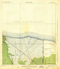
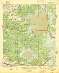
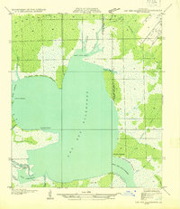 1932 Lac Des Allemands NE1932 Print · USGSCoastal Louisiana at the start of the 1930s is revealed through the intricate bayous and marshlands surrounding Lac Des Allemands. Trace the early drainage patterns and landforms from Carlin Pointe to the Vacherie Canal and Bayou Fortier.
 - 1934 Map of Springfield
 1934 Springfield1934 Print · USGSLivingston Parish in the early 1930s is a landscape of complex waterways and small riverfront settlements. Genealogists can trace family roots through sites like Davidson Cem, the Hungarian Sch, and many historic landings including Magnolia Ldg.2 unique versions available
 - 1935 Map of Laplace
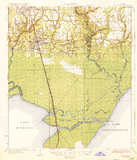
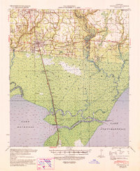
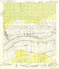
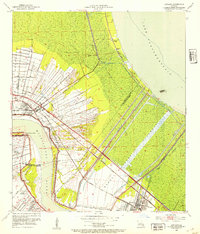
 1935 Laplace1935 Print · USGSSt. John the Baptist Parish and St. Charles Parish appear here in the mid-1930s during the early years of the massive Bonnet Carre Spillway project. Genealogists can locate riverfront landmarks like Trinity Plantation and early settlements including Frenier and Lucy.
 - 1935 Map of Covington
 1935 Covington1935 Print · USGSSt. Tammany Parish thrived as a river and rail hub during the mid-1930s, anchored by the bustling towns along Lake Pontchartrain. Researchers can trace the path of the Illinois Central RR and locate local landmarks like the Rosenwald Sch or the Chefuncte LH.3 unique versions available
 - 1935 Map of Ponchatoula
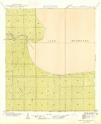
 1935 Ponchatoula1935 Print · USGSCoastal Tangipahoa Parish is seen here in the mid-1930s, where the railroad and early highways began to bridge the gap between the piney woods and the great lakes. Researchers can locate family landmarks like Mitchell Cemetery or trace the old routes to the Manchac Akers Post Office and Jones Island.2 unique versions available
 - 1936 Map of Ruddock
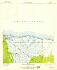
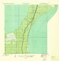 1936 Ruddock1936 Print · USGSSt. John the Baptist Parish marshlands are shown in the mid-1930s as a narrow rail and road corridor between the great lakes. Genealogists and historians can trace the precise locations of Ruddock, Jasmin, and Napton-Sta along the Illinois Central.
 - 1936 Map of Bonnet Carre, 1937 Print
 1936 Bonnet Carre1937 Print · USGSThe Louisiana river parishes are shown in transition during the 1930s as massive flood control projects reshape the landscape. Genealogists and researchers can trace the historic Woodland Plantation, locate the Killona Sch, or study the footprints of rail-side towns like Frenier and Laplace.
 - 1936 Map of Spanish Fort, 1938 Print
 1936 Spanish Fort1938 Print · USGSThe New Orleans lakefront in the mid-1930s reveals a landscape of leisure and engineering as the city expanded toward the water. Trace the footprints of Pontchartrain Beach Amusement Park, the historic docks at Milneburg, and the path of the Old Spanish Trail.
 - 1938 Map of La Branche
 1938 La Branche1938 Print · USGSCoastal St. Charles Parish is captured here in the late 1930s, showing a transition from natural marshland to a managed hydraulic landscape. Researchers can trace the Illinois Central railroad through Labranche and locate the engineered Bonnet Carre Floodway.2 unique versions available
 - 1939 Map of Ponchatoula
 1939 Ponchatoula1939 Print · USGSLouisiana's Florida Parishes are captured here in the late thirties, where the rail lines of the Illinois Central meet the cypress swamps. Researchers can trace family roots at Wetmore Cem or locate the remote Pass Manchac LH and the lumber camps of the Louisiana Cypress Lumber Co.
 - 1939 Map of Covington
 1939 Covington1939 Print · USGSSt. Tammany Parish thrived as a river and rail corridor before mid-century, where the Bogue Falaya met the northern shore of Lake Pontchartrain. Genealogists and historians can trace family roots through the Rosenwald Sch, Little Zion Ch & Cem, and the old rail routes of the Illinois Central.
 - 1939 Map of Springfield
 1939 Springfield1939 Print · USGSCoastal Louisiana at the end of the Depression era reveals a world of river landings and remote parish settlements. Genealogists and researchers can locate family sites like Davidson Cem, local schools such as Hungarian Sch, and numerous river points including Warsaw Log.2 unique versions available
 - 1941 Map of Lac Des Allemands
 1941 Lac Des Allemands1941 Print · USGSLafourche Parish at the start of the 1940s reveals a water-bound economy of bayous, swamps, and sugar plantations. Genealogists and researchers can trace local church and school sites like St Lawrence Ch and Choctaw Sch alongside historic holdings such as Melodia Plantation.
 - 1944 Map of Lac Des Allemands
 1944 Lac Des Allemands1944 Print · USGSThe swampy interface of St. James and Lafourche parishes comes alive in this mid-century survey of the Mississippi River delta. Genealogists can trace family roots at Golden Star Plantation, Webster Plantation, and community landmarks like St Lawrence Ch.2 unique versions available
 - 1945 Map of New Orleans
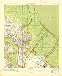
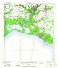
 1945 New Orleans1945 Print · USGSCoastal Louisiana and the Mississippi delta are captured here just after the war, showing the region's transition into a modern industrial and transit hub. Genealogists can trace family settlements along Bayou Teche or identify rail stops for the Illinois Central and Texas & Pacific lines.
 - 1946 Map of North of Garyville
 1946 North of Garyville1946 Print · USGSCoastal wetlands near the southern edge of the Maurepas basin are shown here in the mid-1940s. Researchers can trace the era's timber and water-borne commerce at Lutcher-Moore Camp and along the winding Blind River.
 - 1946 Map of Lutcher
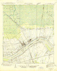 1946 Lutcher1946 Print · USGSSt. James Parish and the riverfront communities of Lutcher and Gramercy are captured here in the mid-forties, showing the intersection of the Mississippi's bend with the local sugar industry. Researchers can trace historic family lands near Paulina or locate the Longview Sugar Mill and St Joseph Ch.
 - 1946 Map of Petite Amite River
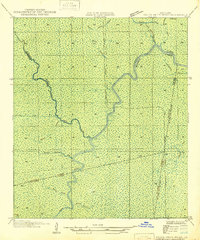 1946 Petite Amite River1946 Print · USGSCoastal Louisiana at the end of the depression era is revealed here as a wild corridor of bayous and shifting parish lines. Trace the path of the Garville Northern (Abandoned) railroad as it cuts through the swamps near Blind River and Black Lake.
 - 1949 Map of Garyville
 1949 Garyville1949 Print · USGSThe Mississippi River corridor comes alive in the late 1940s, showing the intersection of rail-and-river commerce and deep-rooted sugar parishes. Trace ancestral roots and industrial history through the Columbia Sugar Mill, St Peters Ch, and the Illinois Central railroad line.
 - 1950 Map of Covington, 1965 Print
 1950 Covington1965 Print · USGSSt. Tammany Parish at mid-century reveals a landscape of river-port towns and growing lakeshore communities before the full expansion of the New Orleans suburbs. Genealogists can trace family sites near White Chapel, St James Ch, and the Rosenwald Sch or follow the historic Illinois Central rail line.
 - 1951 Map of Ponchatoula, 1953 Print
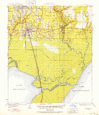 1951 Ponchatoula1953 Print · USGSThe swampy interface of Tangipahoa Parish is captured in the early fifties as the railroad reached across the wetlands toward New Orleans. Trace historical footprints at Manchac Akers P.O., find family sites like Edwards Cem, or locate the Pass Manchac L H.3 unique versions available
 - 1952 Map of Ruddock, 1953 Print
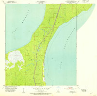 1952 Ruddock1953 Print · USGSThe Louisiana wetlands between the Great Lakes are captured here in the early fifties, centered on the railroad siding of Ruddock. Trace the Illinois Central rail line and local landmarks like the Cem and Ruddock Canal.
 - 1952 Map of Laplace, 1953 Print
 1952 Laplace1953 Print · USGSIn the early fifties, this area of the river parishes was defined by the intersection of industrial growth and massive flood control projects. Researchers can trace the riverfront footprints of Glen Dale Plantation and the Old Killona Sch alongside the sprawling Bonnet Carre Floodway.
 - 1952 Map of La Branche, 1953 Print
 1952 La Branche1953 Print · USGSThe St. Charles Parish shoreline at mid-century reveals a landscape of industrial marshland and massive flood control projects. Historians can trace the Illinois Central rail line through the wetlands, past an Oil Field and the Bonnet Carre Floodway.2 unique versions available
Showing maps 1-25 of 67
Top cities of St. John the Baptist Parish
Frequently asked questions
- What are the different types of historical maps available for St. John the Baptist Parish?
- What is the oldest map of St. John the Baptist Parish?
- Where can I purchase historical maps of St. John the Baptist Parish for my home or office?
- Where can I download high-res historical maps of St. John the Baptist Parish?
- Are there historical topographic maps available for St. John the Baptist Parish?
- Is there historical aerial imagery available for St. John the Baptist Parish?
- Where are historical maps of St. John the Baptist Parish sourced from?