1900s (20th Century) Maps of Ruddock, Louisiana
Explore 11 historic maps of Ruddock from the 1900s (20th Century). These maps offer a rare glimpse into what life looked like during the 1900s — showing old roads, neighborhoods, homes, and landmarks that have changed or disappeared over time.
Whether you're researching your family's past, planning a metal detecting trip, or studying how Ruddock's landscape evolved across the 1900s, these high-resolution maps are a powerful tool for exploring the history of this region.
- Focus on a specific era: All maps on this page are from the 1900s, giving you a focused view of this time period.
- See what’s changed: Compare century-old streets, trails, and buildings to today's modern landscape using overlays and satellite layers.
- Research with precision: Use these maps for genealogy, historical research, land use analysis, or educational projects.
- View, download, or print: Maps are fully viewable online in high resolution, and can be downloaded or printed for your own records.
Start exploring Ruddock's history through authentic maps from the 1900s. This is your window into the past.
Ruddock, LA maps
(11)- 1936 Map of Ruddock
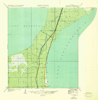 1936 Ruddock1936 Print · USGSSt. John the Baptist Parish marshlands are shown in the mid-1930s as a narrow rail and road corridor between the great lakes. Genealogists and historians can trace the precise locations of Ruddock, Jasmin, and Napton-Sta along the Illinois Central.
 - 1936 Map of Bonnet Carre, 1937 Print
 1936 Bonnet Carre1937 Print · USGSThe Louisiana river parishes are shown in transition during the 1930s as massive flood control projects reshape the landscape. Genealogists and researchers can trace the historic Woodland Plantation, locate the Killona Sch, or study the footprints of rail-side towns like Frenier and Laplace.
 - 1952 Map of Ruddock, 1953 Print
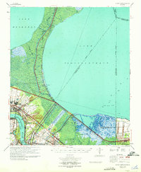
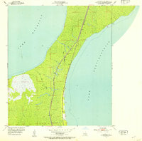 1952 Ruddock1953 Print · USGSThe Louisiana wetlands between the Great Lakes are captured here in the early fifties, centered on the railroad siding of Ruddock. Trace the Illinois Central rail line and local landmarks like the Cem and Ruddock Canal.
 - 1954 Map of Baton Rouge, 1974 Print
 1954 Baton Rouge1974 Print · USGSSoutheast Louisiana in the mid-fifties is captured here during a period of transition for its river and rail economies. Researchers can trace the path of the Mississippi River and find landmarks like the Bonnet Carre Spillway and Bayou Plaquemine.2 unique versions available
 - 1956 Map of Baton Rouge
 1956 Baton Rouge1956 Print · USGSSouth Louisiana at the height of the mid-century oil boom shows a landscape of river oxbows and rising industry. Researchers can trace family roots through river towns like Scotlandville or locate early industrial sites and Oil wells near Lake Maurepas.
 - 1957 Map of Bonnet Carre, 1958 Print
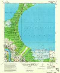 1957 Bonnet Carre1958 Print · USGSCoastal Louisiana at the height of mid-century industrialization reveals a landscape shaped by river management and oil discovery. Trace the footprints of Anchor Plantation, follow the Illinois Central through Ruddock, and see the vast Bonnet Carre Floodway.
 - 1961 Map of Baton Rouge, 1966 Print
 1961 Baton Rouge1966 Print · USGSSoutheastern Louisiana in the early sixties remains a landscape of deep river bends and sprawling coastal lakes. Genealogists and historians can trace the rail-and-river economy through landmarks like Free-Nigger Point, Donaldsonville, and the Illinois Central Railroad.
 - 1962 Map of Baton Rouge
 1962 Baton Rouge1962 Print · USGSSouth Louisiana in the early sixties reveals a landscape of river-bend parishes and emerging interstate corridors. Genealogists and historians can trace family roots through historic river towns like Donaldsonville and Plaquemine, or follow the path of the Illinois Central Railroad through the swamp basins.
 - 1967 Map of Ruddock, 1968 Print
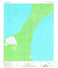 1967 Ruddock1968 Print · USGSThe Isthmus of Manchac is shown here in the late sixties, where the cypress swamps separate two major coastal lakes. Genealogists and historians can trace the Illinois Central rail line to the settlement of Ruddock and a nearby Cem.3 unique versions available
 - 1969 Map of Bonnet Carre, 1971 Print
 1969 Bonnet Carre1971 Print · USGSThe Louisiana river parishes are shown in a transitional era of flood control and petroleum expansion during the late sixties. Genealogists and historians can trace riverside settlements like Montz and Lucy, or follow the industrial corridor near the Bonnet Carre Spillway.
 - 1983 Map of Ponchatoula, 1984 Print
 1983 Ponchatoula1984 Print · USGSThe Lake Pontchartrain Basin and the River Parishes come into focus during the early 1980s, showcasing the region's complex water-dependent geography. Researchers can trace the rail routes of the Illinois Central Gulf Railroad and explore landmarks from Pass Manchac to Donaldsonville.2 unique versions available
End of results
Showing maps 1-11 of 11
Top cities near Ruddock
- Kenner historical maps
- LaPlace historical maps
- Ponchatoula historical maps
- Killian historical maps
- Springfield historical maps
Frequently asked questions
- What are the different types of historical maps available for Ruddock?
- What is the oldest map of Ruddock?
- Where can I purchase historical maps of Ruddock for my home or office?
- Where can I download high-res historical maps of Ruddock?
- Are there historical topographic maps available for Ruddock?
- Is there historical aerial imagery available for Ruddock?
- Where are historical maps of Ruddock sourced from?