
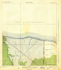
1936 Map of Ruddock
USGS Topo · Published 1936About this map
Lake Pontchartrain and Lake Maurepas define this narrow corridor of marshland in St. John the Baptist Parish during the mid-1930s. The landscape is dominated by the Illinois Central railroad and Highway No 51, which provide a vital north-south artery through the wetlands. This survey, compiled in part from aerial photography by the Air Corps, reveals the precise positioning of small rail-dependent settlements like Ruddock, Jasmin, and Napton-Sta.
Find a feature on this map
15 named features on this map. Tap any name to fly to it.
Don’t see what you’re looking for? This feature index may not catch every label — zoom into the map to look around manually.
Map Details
Editions of this 1936 Ruddock Map
This is the sole edition of this map. No revisions or reprints were ever made.
Other maps of this area

1892 · Mount Airy
USGS Topo · 1:62,500

1892 · Bonnet Carre
USGS Topo · 1:62,500

1934 · Springfield
USGS Topo · 1:62,500

1935 · Laplace
USGS Topo · 1:31,680

1935 · Ponchatoula
USGS Topo · 1:62,500

1936 · Bonnet Carre
USGS Topo · 1:62,500
1938 · La Branche
USGS Topo · 1:31,680

1939 · Ponchatoula
USGS Topo · 1:62,500

1939 · Springfield
USGS Topo · 1:62,500

1946 · North of Garyville
USGS Topo · 1:31,680