1990s Maps of Newellton, Louisiana
Explore 2 historic maps of Newellton from the 1990s. These maps offer a rare glimpse into what life looked like during the 1990s — showing old roads, neighborhoods, homes, and landmarks that have changed or disappeared over time.
Whether you're researching your family's past, planning a metal detecting trip, or studying how Newellton's landscape evolved across the 1990s, these high-resolution maps are a powerful tool for exploring the history of this region.
- Focus on a specific era: All maps on this page are from the 1990s, giving you a focused view of this time period.
- See what’s changed: Compare century-old streets, trails, and buildings to today's modern landscape using overlays and satellite layers.
- Research with precision: Use these maps for genealogy, historical research, land use analysis, or educational projects.
- View, download, or print: Maps are fully viewable online in high resolution, and can be downloaded or printed for your own records.
Start exploring Newellton's history through authentic maps from the 1990s. This is your window into the past.
Newellton, LA maps
(2)- 1994 Map of Saranac, 1997 Print
 1994 Saranac1997 Print · USGSTensas Parish in the mid-1990s reveals a delta landscape defined by meandering bayous and deep-rooted settlements. Trace the geography of the Mississippi floodplain through sites like Newellton, the Indian Mounds, and the winding waters of Big Choctaw Bayou.
 - 1994 Map of Newellton, 1997 Print
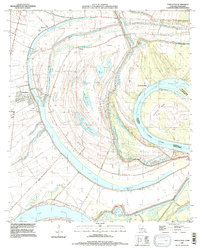 1994 Newellton1997 Print · USGSThe Lower Mississippi River loops through Tensas Parish in the 1990s, revealing a landscape shaped by ancient oxbows and river landings. Genealogists can locate several family burial grounds, such as Indian Mounds Cem, Elk Ridge Cem, and Newellton Cem.
End of results
Showing maps 1-2 of 2
Top cities near Newellton
Frequently asked questions
- What are the different types of historical maps available for Newellton?
- What is the oldest map of Newellton?
- Where can I purchase historical maps of Newellton for my home or office?
- Where can I download high-res historical maps of Newellton?
- Are there historical topographic maps available for Newellton?
- Is there historical aerial imagery available for Newellton?
- Where are historical maps of Newellton sourced from?