1940s Maps of Point-Aux-Chenes, Louisiana
Explore 3 historic maps of Point-Aux-Chenes from the 1940s. These maps offer a rare glimpse into what life looked like during the 1940s — showing old roads, neighborhoods, homes, and landmarks that have changed or disappeared over time.
Whether you're researching your family's past, planning a metal detecting trip, or studying how Point-Aux-Chenes's landscape evolved across the 1940s, these high-resolution maps are a powerful tool for exploring the history of this region.
- Focus on a specific era: All maps on this page are from the 1940s, giving you a focused view of this time period.
- See what’s changed: Compare century-old streets, trails, and buildings to today's modern landscape using overlays and satellite layers.
- Research with precision: Use these maps for genealogy, historical research, land use analysis, or educational projects.
- View, download, or print: Maps are fully viewable online in high resolution, and can be downloaded or printed for your own records.
Start exploring Point-Aux-Chenes's history through authentic maps from the 1940s. This is your window into the past.
Point-Aux-Chenes, LA maps
(3)- 1941 Map of Dulac
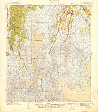 1941 Dulac1941 Print · USGSCoastal Louisiana in the late thirties reveals a world of water-based commerce and ridge-line settlements. Genealogists can trace family names at St Michaels Plantation, locate schools like Morning Star Sch, or study the Dugas Cem and Indian Mound.
 - 1944 Map of Dulac
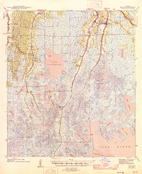 1944 Dulac1944 Print · USGSCoastal Terrebonne Parish in the 1940s is defined by its finger-like bayou settlements and expansive marshes. Genealogists can trace family roots at St Michaels Plantation, Theriot P O, and cemetery sites like Dugas Cem.
 - 1945 Map of New Orleans
 1945 New Orleans1945 Print · USGSCoastal Louisiana and the Mississippi delta are captured here just after the war, showing the region's transition into a modern industrial and transit hub. Genealogists can trace family settlements along Bayou Teche or identify rail stops for the Illinois Central and Texas & Pacific lines.
End of results
Showing maps 1-3 of 3
Top cities near Point-Aux-Chenes
- Houma historical maps
- Chauvin historical maps
- Lockport historical maps
- Dulac historical maps
- Montegut historical maps
Frequently asked questions
- What are the different types of historical maps available for Point-Aux-Chenes?
- What is the oldest map of Point-Aux-Chenes?
- Where can I purchase historical maps of Point-Aux-Chenes for my home or office?
- Where can I download high-res historical maps of Point-Aux-Chenes?
- Are there historical topographic maps available for Point-Aux-Chenes?
- Is there historical aerial imagery available for Point-Aux-Chenes?
- Where are historical maps of Point-Aux-Chenes sourced from?