1970s Maps of Franklinton, Louisiana
Explore 2 historic maps of Franklinton from the 1970s. These maps offer a rare glimpse into what life looked like during the 1970s — showing old roads, neighborhoods, homes, and landmarks that have changed or disappeared over time.
Whether you're researching your family's past, planning a metal detecting trip, or studying how Franklinton's landscape evolved across the 1970s, these high-resolution maps are a powerful tool for exploring the history of this region.
- Focus on a specific era: All maps on this page are from the 1970s, giving you a focused view of this time period.
- See what’s changed: Compare century-old streets, trails, and buildings to today's modern landscape using overlays and satellite layers.
- Research with precision: Use these maps for genealogy, historical research, land use analysis, or educational projects.
- View, download, or print: Maps are fully viewable online in high resolution, and can be downloaded or printed for your own records.
Start exploring Franklinton's history through authentic maps from the 1970s. This is your window into the past.
Franklinton, LA maps
(2)- 1976 Map of Franklinton SE, 1977 Print
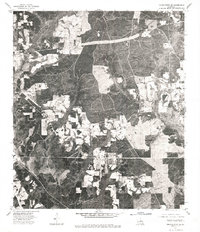 1976 Franklinton SE1977 Print · USGSWashington Parish in the mid-seventies is revealed through direct aerial imagery in this specialized orthophotomap. Researchers can examine the physical layout of the Sheridan settlement and trace the exact footprint of forest clearings and rural homesteads.
 - 1976 Map of Franklinton SW, 1977 Print
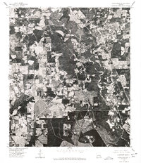 1976 Franklinton SW1977 Print · USGSWashington Parish at the height of the 1970s is captured here through detailed aerial photography, showing the town of Franklinton and the surrounding river bottomlands. Researchers can trace the winding course of the Bogue Chitto and examine the clear-cut edges of rural homesteads and timber operations.
End of results
Showing maps 1-2 of 2
Top cities near Franklinton
Frequently asked questions
- What are the different types of historical maps available for Franklinton?
- What is the oldest map of Franklinton?
- Where can I purchase historical maps of Franklinton for my home or office?
- Where can I download high-res historical maps of Franklinton?
- Are there historical topographic maps available for Franklinton?
- Is there historical aerial imagery available for Franklinton?
- Where are historical maps of Franklinton sourced from?