1960s Maps of West Baton Rouge Parish, Louisiana
Explore 14 historic maps of West Baton Rouge Parish from the 1960s. These maps offer a rare glimpse into what life looked like during the 1960s — showing old roads, neighborhoods, homes, and landmarks that have changed or disappeared over time.
Whether you're researching your family's past, planning a metal detecting trip, or studying how West Baton Rouge Parish's landscape evolved across the 1960s, these high-resolution maps are a powerful tool for exploring the history of this region.
- Focus on a specific era: All maps on this page are from the 1960s, giving you a focused view of this time period.
- See what’s changed: Compare century-old streets, trails, and buildings to today's modern landscape using overlays and satellite layers.
- Research with precision: Use these maps for genealogy, historical research, land use analysis, or educational projects.
- View, download, or print: Maps are fully viewable online in high resolution, and can be downloaded or printed for your own records.
Start exploring West Baton Rouge Parish's history through authentic maps from the 1960s. This is your window into the past.
West Baton Rouge Parish, LA maps
(14)- 1961 Map of Baton Rouge, 1966 Print
 1961 Baton Rouge1966 Print · USGSSoutheastern Louisiana in the early sixties remains a landscape of deep river bends and sprawling coastal lakes. Genealogists and historians can trace the rail-and-river economy through landmarks like Free-Nigger Point, Donaldsonville, and the Illinois Central Railroad.
 - 1962 Map of Baton Rouge
 1962 Baton Rouge1962 Print · USGSSouth Louisiana in the early sixties reveals a landscape of river-bend parishes and emerging interstate corridors. Genealogists and historians can trace family roots through historic river towns like Donaldsonville and Plaquemine, or follow the path of the Illinois Central Railroad through the swamp basins.
 - 1962 Map of Erwinville, 1964 Print
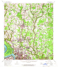
 1962 Erwinville1964 Print · USGSThe West Baton Rouge and Pointe Coupee parish line comes alive in the early 1960s, showing a landscape defined by the False River and railroad-driven commerce. Genealogists can trace family footprints through sites like St Peters Ch, St Ambrose Cem, and the old post office at Erwinville P O.2 unique versions available
 - 1962 Map of Grosse Tete, 1965 Print
 1962 Grosse Tete1965 Print · USGSThe river parishes of Louisiana come into focus during the early sixties, showing a landscape defined by industrial oil fields and historic riverfront estates. Genealogists can trace family footprints through sites like Indian Village, Levy Sch, and Grace Memorial Park Cem.2 unique versions available
 - 1963 Map of Plaquemine, 1964 Print
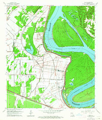
 1963 Plaquemine1964 Print · USGSIberville Parish and the Mississippi River loops are captured here in the early sixties as the sugar and rail economies remained central to the landscape. Genealogists can trace family roots through named estates like St Louis Plantation and settlements such as Morrisonville and Seymourville.5 unique versions available
 - 1963 Map of Walls, 1964 Print
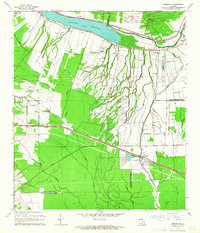
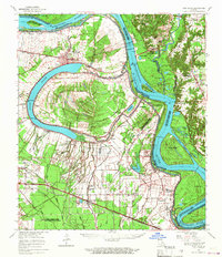
 1963 Walls1964 Print · USGSWest Baton Rouge Parish in the early 1960s shows a landscape defined by the Mississippi River and its massive levee. Genealogists and local historians can trace family roots through settlements like Smithfield, Chamberlin, and Bueche, as well as numerous rural churches including Zion Traveler Ch.5 unique versions available
 - 1963 Map of Scotlandville, 1964 Print
 1963 Scotlandville1964 Print · USGSThe northern reaches of Baton Rouge during the early sixties show a landscape balancing institutional growth with the industrial riverfront. Researchers can trace the footprints of Southern University, Leland College, and local landmarks like Free Negro Point.5 unique versions available
 - 1963 Map of Baton Rouge West, 1964 Print
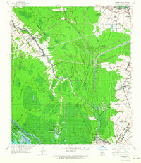
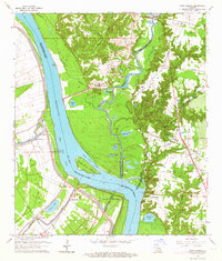
 1963 Baton Rouge West1964 Print · USGSBaton Rouge and the river parishes are captured in the early sixties as industrial expansion meets established plantation history. Trace the development of LSU, the busy Port Allen waterfront, and historic sites like Poplar Grove Plantation.5 unique versions available
 - 1963 Map of Port Hudson, 1964 Print
 1963 Port Hudson1964 Print · USGSThe Mississippi River bends through the Louisiana parishes during the early sixties, revealing a landscape of historic river crossings and rail lines. Genealogists can locate family landmarks like Port Hudson National Cemetery, Hermitage, and Mt Pilgrim Ch Cem.5 unique versions available
 - 1963 Map of Zachary, 1967 Print
 1963 Zachary1967 Print · USGSThe northern corridor of East Baton Rouge Parish shows a blend of river industry and growing suburban centers in the early sixties. Genealogists can locate dozens of church-linked burial sites like Azalea Rest Cem and schools such as Leland College or Southern University.2 unique versions available
 - 1963 Map of New Roads, 1967 Print
 1963 New Roads1967 Print · USGSThe oxbows and river bends of Pointe Coupee and West Baton Rouge Parishes come to life in this mid-sixties survey. Researchers can trace family roots through numerous sites like Torbert P O, St Alma Sch, and the Port Hudson National Cem.2 unique versions available
 - 1963 Map of Baton Rouge, 1967 Print
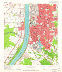
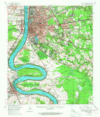 1963 Baton Rouge1967 Print · USGSBaton Rouge and its riverfront suburbs come alive in the early sixties, showing the city's expansion alongside its deep-rooted river culture. Trace the footprints of mid-century life from LSU to the Burtville Oil Field and historic Cottage Plantation.2 unique versions available
 - 1965 Map of Baton Rouge
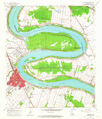
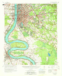 1965 Baton Rouge1965 Print · USGSBaton Rouge and the Mississippi River corridor are captured here in the mid-sixties, showcasing a landscape where urban expansion met deep-rooted river history. Genealogists and historians can trace numerous named estates and settlements, from St Louis Plantation and Morrisonville to Soulouque and Port Allen.
 - 1965 Map of New Roads
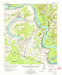 1965 New Roads1965 Print · USGSThe oxbow of False River and the Mississippi's ever-changing course dominate this mid-century survey of Pointe Coupee Parish. Genealogists and historians can trace the family names and rural hamlets of the plantation era, including New Roads, Port Hudson National Cem, and the St Ambrose Cem.
End of results
Showing maps 1-14 of 14
Top cities of West Baton Rouge Parish
Frequently asked questions
- What are the different types of historical maps available for West Baton Rouge Parish?
- What is the oldest map of West Baton Rouge Parish?
- Where can I purchase historical maps of West Baton Rouge Parish for my home or office?
- Where can I download high-res historical maps of West Baton Rouge Parish?
- Are there historical topographic maps available for West Baton Rouge Parish?
- Is there historical aerial imagery available for West Baton Rouge Parish?
- Where are historical maps of West Baton Rouge Parish sourced from?