1950s Maps of West Carroll Parish, Louisiana
Explore 8 historic maps of West Carroll Parish from the 1950s. These maps offer a rare glimpse into what life looked like during the 1950s — showing old roads, neighborhoods, homes, and landmarks that have changed or disappeared over time.
Whether you're researching your family's past, planning a metal detecting trip, or studying how West Carroll Parish's landscape evolved across the 1950s, these high-resolution maps are a powerful tool for exploring the history of this region.
- Focus on a specific era: All maps on this page are from the 1950s, giving you a focused view of this time period.
- See what’s changed: Compare century-old streets, trails, and buildings to today's modern landscape using overlays and satellite layers.
- Research with precision: Use these maps for genealogy, historical research, land use analysis, or educational projects.
- View, download, or print: Maps are fully viewable online in high resolution, and can be downloaded or printed for your own records.
Start exploring West Carroll Parish's history through authentic maps from the 1950s. This is your window into the past.
West Carroll Parish, LA maps
(8)- 1953 Map of Greenwood, 1966 Print
 1953 Greenwood1966 Print · USGSThe Mississippi Delta in the mid-fifties is captured here as a thriving network of river towns, railroads, and oxbow lakes. Researchers can trace the legacy of the Illinois Central Railroad and locate landmarks like the State Penal Farm and Greenville Air Force Base.5 unique versions available
 - 1955 Map of Jackson
 1955 Jackson1955 Print · USGSThe Lower Mississippi Valley at the middle of the century reveals a landscape of deep river meanders and growing rail hubs. Genealogists and historians can trace the mid-century footprints of Vicksburg National Military Park, old river landings at Port Gibson, and the rail corridors of the Illinois Central Railroad.3 unique versions available
 - 1956 Map of Greenwood
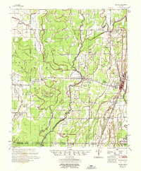
 1956 Greenwood1956 Print · USGSThe Mississippi Delta in the mid-fifties is captured here during a period of significant military and agricultural activity. Researchers can trace the rail lines of the Illinois Central RR, find the Greenville Air Force Base, or locate the State Penal Farm.
 - 1957 Map of Eudora
 1957 Eudora1957 Print · USGSSoutheast Arkansas and Northeast Louisiana are captured here in the late 1950s, showing a delta landscape defined by winding bayous and rural community life. Researchers can trace family roots through numerous local landmarks like Masons Cem, Ross Van Ness Sch, and Holly Sch.2 unique versions available
 - 1958 Map of Oak Grove
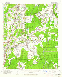
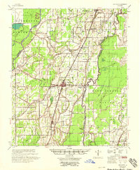 1958 Oak Grove1958 Print · USGSNortheast Louisiana in the late fifties is captured here as a landscape of bayous and railroad towns. Researchers can trace family history through numerous rural churches like Sardis Ch and Locust Grove Ch, or locate the historic Lanes Ferry crossing.
 - 1958 Map of Hurricane
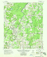 1958 Hurricane1958 Print · USGSNortheast Louisiana parishes are shown here in the late fifties, where the river and rail lines dictated the pace of rural life. Researchers can trace family roots through numerous country sites like Wimberley Cem, Trails End Ch, and MOUND LDG.
 - 1958 Map of Bonita
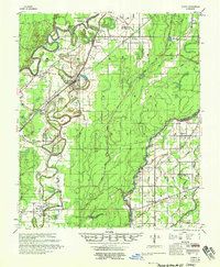 1958 Bonita1958 Print · USGSLouisiana's northeastern corner comes alive in the late fifties, showing the bayou-driven landscape of the Morehouse and West Carroll border. Trace family history and rural community life through specific landmarks like 12 Heart Cem, McGloty Sch New Hope Ch, and Jones.2 unique versions available
 - 1959 Map of Mitchiner, 1962 Print
 1959 Mitchiner1962 Print · USGSNortheastern Louisiana at the end of the fifties reveals a landscape of ancient earthworks and rising energy production. Genealogists can trace family roots through Bethany Cem & Ch, Adams Sch, and the historical significance of Poverty Pt.2 unique versions available
End of results
Showing maps 1-8 of 8
Top cities of West Carroll Parish
- Oak Grove historical maps
- Kilbourne historical maps
- Epps historical maps
- Forest historical maps
- Pioneer historical maps
Frequently asked questions
- What are the different types of historical maps available for West Carroll Parish?
- What is the oldest map of West Carroll Parish?
- Where can I purchase historical maps of West Carroll Parish for my home or office?
- Where can I download high-res historical maps of West Carroll Parish?
- Are there historical topographic maps available for West Carroll Parish?
- Is there historical aerial imagery available for West Carroll Parish?
- Where are historical maps of West Carroll Parish sourced from?