Old Maps of West Carroll Parish, Louisiana for Hiking & Exploration
Hike through history with 105 historic maps of West Carroll Parish. Explore old trails, ghost towns, and forgotten backroads — perfect for outdoor adventurers and local explorers.
- Rediscover forgotten places: Map out old mining camps, roads, and footpaths that no longer exist on modern maps.
- Layer with modern tools: Combine with LiDAR or satellite views to plan hikes through historical terrain.
- Made for exploration: Popular among hikers, overlanders, and local history lovers.
Use these maps to find adventure and explore the hidden past of West Carroll Parish.
West Carroll Parish, LA maps
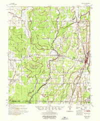
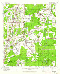
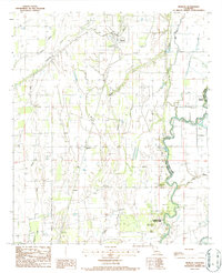
(105)- 1909 Map of Baxter Bayou
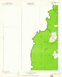
 1909 Baxter Bayou1909 Print · USGSLouisiana's delta country at the end of the first decade of the twentieth century shows a landscape tied to its winding waterways. Researchers can locate early river crossings and oxbows like Lanes Ferry Bridge, Corbins Ferry (Abandoned), and Johnson Lake.
 - 1909 Map of Ashton Bridge, 1961 Print
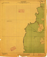
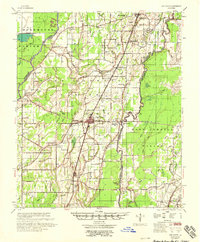
 1909 Ashton Bridge1961 Print · USGSThe Louisiana delta country at the turn of the century is documented here along the winding Bayou Macon. Researchers can trace early industry and transport through Cook and McLean's Sawmill, a Tram Road, and the original Ashton Bridge.
 - 1911 Map of Baxter Bayou, 1961 Print
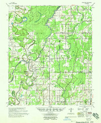
 1911 Baxter Bayou1961 Print · USGSLouisiana's Mississippi Delta region appears as a network of winding waterways and large agricultural estates just after the turn of the century. Trace the boundaries of Tompkins Plantation, find the Lickskillet School, or locate the abandoned Corbins Ferry along Macon Bayou.
 - 1912 Map of Ashton Bridge
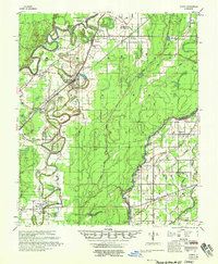
 1912 Ashton Bridge1912 Print · USGSNortheast Louisiana timber and transit are captured here in the years before the Great War. Researchers can trace the industrial footprint of Cook and McLean's Sawmill and the early Tram Road crossing Bayou Macon.3 unique versions available
 - 1914 Map of Baxter Bayou
 1914 Baxter Bayou1914 Print · USGSEast Carroll Parish in the early twentieth century is a landscape of expansive plantations and winding delta waterways. Family historians can trace ancestral lands at Tompkins Plantation or Bowie Plantation, and locate rural landmarks like Lickskillet School.2 unique versions available
 - 1935 Map of Hurricane, 1936 Print
 1935 Hurricane1936 Print · USGSRichland and Morehouse Parishes are depicted in the mid-1930s as a complex network of bayous and river islands. Genealogists can trace rural life through landmarks like Point Jefferson, Antioch Ch, and several local schools including Prospect Sch.
 - 1935 Map of Oak Grove, 1938 Print
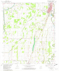
 1935 Oak Grove1938 Print · USGSNortheastern Louisiana in the mid-1930s is mapped here at the height of its rail and timber era. Researchers can trace the El Bruce Co Logging Tramway, find the Hill Sch, and locate family sites near Oak Grove and Forest.
 - 1935 Map of Bonita, 1943 Print
 1935 Bonita1943 Print · USGSLouisiana's delta country is captured here during the mid-1930s, showing a landscape defined by meandering bayous and small farming settlements. Genealogists can locate family landmarks like Mound Chapel Ch, the Johnson Sch, and the riverside Loverett Ferry.2 unique versions available
 - 1936 Map of Eudora, 1943 Print
 1936 Eudora1943 Print · USGSSoutheast Arkansas and northeast Louisiana are captured here in the mid-1930s, showing a landscape shaped by water management and rail transport. Researchers can trace the early energy infrastructure of the Standard Oil Pipe Line or locate rural landmarks like Holly Ridge Ch and Empire.
 - 1953 Map of Greenwood, 1966 Print
 1953 Greenwood1966 Print · USGSThe Mississippi Delta in the mid-fifties is captured here as a thriving network of river towns, railroads, and oxbow lakes. Researchers can trace the legacy of the Illinois Central Railroad and locate landmarks like the State Penal Farm and Greenville Air Force Base.5 unique versions available
 - 1955 Map of Jackson
 1955 Jackson1955 Print · USGSThe Lower Mississippi Valley at the middle of the century reveals a landscape of deep river meanders and growing rail hubs. Genealogists and historians can trace the mid-century footprints of Vicksburg National Military Park, old river landings at Port Gibson, and the rail corridors of the Illinois Central Railroad.3 unique versions available
 - 1956 Map of Greenwood
 1956 Greenwood1956 Print · USGSThe Mississippi Delta in the mid-fifties is captured here during a period of significant military and agricultural activity. Researchers can trace the rail lines of the Illinois Central RR, find the Greenville Air Force Base, or locate the State Penal Farm.
 - 1957 Map of Eudora
 1957 Eudora1957 Print · USGSSoutheast Arkansas and Northeast Louisiana are captured here in the late 1950s, showing a delta landscape defined by winding bayous and rural community life. Researchers can trace family roots through numerous local landmarks like Masons Cem, Ross Van Ness Sch, and Holly Sch.2 unique versions available
 - 1958 Map of Oak Grove
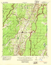
 1958 Oak Grove1958 Print · USGSNortheast Louisiana in the late fifties is captured here as a landscape of bayous and railroad towns. Researchers can trace family history through numerous rural churches like Sardis Ch and Locust Grove Ch, or locate the historic Lanes Ferry crossing.
 - 1958 Map of Hurricane
 1958 Hurricane1958 Print · USGSNortheast Louisiana parishes are shown here in the late fifties, where the river and rail lines dictated the pace of rural life. Researchers can trace family roots through numerous country sites like Wimberley Cem, Trails End Ch, and MOUND LDG.
 - 1958 Map of Bonita
 1958 Bonita1958 Print · USGSLouisiana's northeastern corner comes alive in the late fifties, showing the bayou-driven landscape of the Morehouse and West Carroll border. Trace family history and rural community life through specific landmarks like 12 Heart Cem, McGloty Sch New Hope Ch, and Jones.2 unique versions available
 - 1959 Map of Mitchiner, 1962 Print
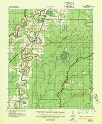
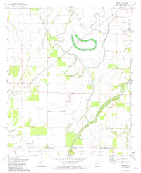
 1959 Mitchiner1962 Print · USGSNortheastern Louisiana at the end of the fifties reveals a landscape of ancient earthworks and rising energy production. Genealogists can trace family roots through Bethany Cem & Ch, Adams Sch, and the historical significance of Poverty Pt.2 unique versions available
 - 1961 Map of Jackson
 1961 Jackson1961 Print · USGSThe Lower Mississippi Delta and the state capital area are captured here during the post-war era of infrastructure expansion. Researchers can trace the complex river oxbows and rail lines connecting Vicksburg, Yazoo City, and the Illinois Central Railroad network.
 - 1962 Map of Jackson
 1962 Jackson1962 Print · USGSThe Mississippi Delta and the state capital region are mapped here in the early sixties, showing a landscape defined by the great river and the growing city of JACKSON. Genealogists can trace family roots through numerous landmarks like Cedar Hill Cem, rural stops on the Illinois Central RR, and historic sites like Champion Hill.2 unique versions available
 - 1981 Map of Eudora South, 1982 Print
 1981 Eudora South1982 Print · USGSThe Arkansas-Louisiana state line is captured here in the early eighties, showcasing a landscape of Delta farming and small-town life. Researchers can locate numerous country churches and cemeteries like Mt Carmel Cem & Ch, Omega Ch, and Masons Cem.
 - 1981 Map of Empire, 1982 Print
 1981 Empire1982 Print · USGSThe Arkansas-Louisiana borderlands come into focus in the early 1980s, revealing a landscape of delta bayous and small rural settlements. Genealogists and local historians can trace family ties at Millers Chapel Cem or locate the community centers of Empire and Green Grove Ch.
 - 1982 Map of Bastrop, 1983 Print
 1982 Bastrop1983 Print · USGSNortheastern Louisiana and the Mississippi River Delta are captured here in the early eighties as a landscape of bayous and river towns. Genealogists and historians can trace small communities like Mer Rouge and Oak Grove or the ancient terrain of Poverty Point State Park.
 - 1986 Map of Crossett
 1986 Crossett1986 Print · USGSSoutheast Arkansas and the Mississippi Delta meet in the mid-1980s, revealing a landscape of rail-linked towns and river bottomlands. Researchers can trace the Missouri Pacific line through Hamburg and Parkdale or locate Millers Chapel and Winterville Mounds State Park.2 unique versions available
 - 1986 Map of Caraway Lake, 1987 Print
 1986 Caraway Lake1987 Print · USGSIn the mid-1980s, the Louisiana delta lands between the Carroll parishes remained a complex network of bayous and drainage canals. Researchers can trace the shifting course of Joes Bayou and locate rural landmarks like Caraway Lake and the Cem.
 - 1986 Map of Pioneer, 1987 Print
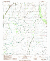
 1986 Pioneer1987 Print · USGSThe West Carroll Parish agricultural landscape is captured here in the mid-1980s, centered on the ancient earthworks of the Mississippi Delta. Genealogists and researchers can trace the rail corridor of the Missouri Pacific through Pioneer and Darnell, or locate the historic Indian Mound near Poverty Point State Park.
Showing maps 1-25 of 105
Top cities of West Carroll Parish
- Oak Grove historical maps
- Kilbourne historical maps
- Epps historical maps
- Forest historical maps
- Pioneer historical maps
Frequently asked questions
- What are the different types of historical maps available for West Carroll Parish?
- What is the oldest map of West Carroll Parish?
- Where can I purchase historical maps of West Carroll Parish for my home or office?
- Where can I download high-res historical maps of West Carroll Parish?
- Are there historical topographic maps available for West Carroll Parish?
- Is there historical aerial imagery available for West Carroll Parish?
- Where are historical maps of West Carroll Parish sourced from?