1980s Maps of Kilbourne, Louisiana
Explore 4 historic maps of Kilbourne from the 1980s. These maps offer a rare glimpse into what life looked like during the 1980s — showing old roads, neighborhoods, homes, and landmarks that have changed or disappeared over time.
Whether you're researching your family's past, planning a metal detecting trip, or studying how Kilbourne's landscape evolved across the 1980s, these high-resolution maps are a powerful tool for exploring the history of this region.
- Focus on a specific era: All maps on this page are from the 1980s, giving you a focused view of this time period.
- See what’s changed: Compare century-old streets, trails, and buildings to today's modern landscape using overlays and satellite layers.
- Research with precision: Use these maps for genealogy, historical research, land use analysis, or educational projects.
- View, download, or print: Maps are fully viewable online in high resolution, and can be downloaded or printed for your own records.
Start exploring Kilbourne's history through authentic maps from the 1980s. This is your window into the past.
Kilbourne, LA maps
(4)- 1981 Map of Eudora South, 1982 Print
 1981 Eudora South1982 Print · USGSThe Arkansas-Louisiana state line is captured here in the early eighties, showcasing a landscape of Delta farming and small-town life. Researchers can locate numerous country churches and cemeteries like Mt Carmel Cem & Ch, Omega Ch, and Masons Cem.
 - 1982 Map of Bastrop, 1983 Print
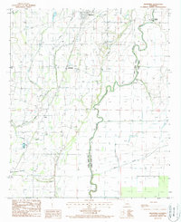
 1982 Bastrop1983 Print · USGSNortheastern Louisiana and the Mississippi River Delta are captured here in the early eighties as a landscape of bayous and river towns. Genealogists and historians can trace small communities like Mer Rouge and Oak Grove or the ancient terrain of Poverty Point State Park.
 - 1986 Map of Crossett
 1986 Crossett1986 Print · USGSSoutheast Arkansas and the Mississippi Delta meet in the mid-1980s, revealing a landscape of rail-linked towns and river bottomlands. Researchers can trace the Missouri Pacific line through Hamburg and Parkdale or locate Millers Chapel and Winterville Mounds State Park.2 unique versions available
 - 1988 Map of Kilbourne
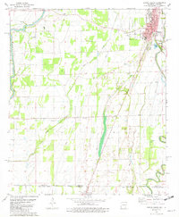
 1988 Kilbourne1988 Print · USGSWest Carroll Parish in the late twentieth century is shown here as a landscape of bayous and agricultural development. Genealogists and historians can trace the Old Railroad Grade through Chickasaw and find landmarks like Ashton Bridge and the Kilbourne post office.
End of results
Showing maps 1-4 of 4
Top cities near Kilbourne
- Lake Providence historical maps
- Eudora historical maps
- Oak Grove historical maps
- Parkdale historical maps
- Forest historical maps
Frequently asked questions
- What are the different types of historical maps available for Kilbourne?
- What is the oldest map of Kilbourne?
- Where can I purchase historical maps of Kilbourne for my home or office?
- Where can I download high-res historical maps of Kilbourne?
- Are there historical topographic maps available for Kilbourne?
- Is there historical aerial imagery available for Kilbourne?
- Where are historical maps of Kilbourne sourced from?