1910s Maps of Turner, Maine
Explore 4 historic maps of Turner from the 1910s. These maps offer a rare glimpse into what life looked like during the 1910s — showing old roads, neighborhoods, homes, and landmarks that have changed or disappeared over time.
Whether you're researching your family's past, planning a metal detecting trip, or studying how Turner's landscape evolved across the 1910s, these high-resolution maps are a powerful tool for exploring the history of this region.
- Focus on a specific era: All maps on this page are from the 1910s, giving you a focused view of this time period.
- See what’s changed: Compare century-old streets, trails, and buildings to today's modern landscape using overlays and satellite layers.
- Research with precision: Use these maps for genealogy, historical research, land use analysis, or educational projects.
- View, download, or print: Maps are fully viewable online in high resolution, and can be downloaded or printed for your own records.
Start exploring Turner's history through authentic maps from the 1910s. This is your window into the past.
Turner, ME maps
(4)- 1910 Map of Livermore, 1959 Print
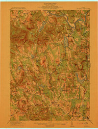
 1910 Livermore1959 Print · USGSMaine's river valleys and lake districts are captured here in the early twentieth century, showing a network of rail-reliant mill towns and rural crossroads. Genealogists can locate family landmarks like Howes Corner and Brettuns Mills, or trace local schools like Saunders School.
 - 1911 Map of Buckfield, 1958 Print
 1911 Buckfield1958 Print · USGSOxford County at the dawn of the twentieth century was a landscape of high ridges and tight river valleys connected by new rail lines. Genealogists can locate dozens of district schoolhouses like Bonney School and rural hubs such as Buckfield and Brettuns Mills Livermore P O.
 - 1912 Map of Livermore
 1912 Livermore1912 Print · USGSMaine's lake district comes to life in this pre-war survey of the Androscoggin River valley. Genealogists and historians can trace old homesteads and landmarks like Brettuns Mills Livermore P O, Strickland Ferry, and Monmouth Academy.5 unique versions available
 - 1913 Map of Buckfield
 1913 Buckfield1913 Print · USGSOxford County towns and mountain peaks are captured here in the early twentieth century. Researchers can trace rural family roots through numerous named schoolhouses like the Meadowview Academy, Jones School, and the Bear Mountain School.5 unique versions available
End of results
Showing maps 1-4 of 4
Top cities near Turner
- Lewiston historical maps
- Auburn historical maps
- Lisbon historical maps
- Winthrop historical maps
- Poland historical maps
- Paris historical maps
See more
Top neighborhoods of Turner
- North Turner historical maps
- Skillings Corner historical maps
- Chase Mills historical maps
- Turner Center historical maps
- South Turner historical maps
- Twin Bridges historical maps
See more
Frequently asked questions
- What are the different types of historical maps available for Turner?
- What is the oldest map of Turner?
- Where can I purchase historical maps of Turner for my home or office?
- Where can I download high-res historical maps of Turner?
- Are there historical topographic maps available for Turner?
- Is there historical aerial imagery available for Turner?
- Where are historical maps of Turner sourced from?