1900s (20th Century) Maps of Allagash, Maine
Explore 15 historic maps of Allagash from the 1900s (20th Century). These maps offer a rare glimpse into what life looked like during the 1900s — showing old roads, neighborhoods, homes, and landmarks that have changed or disappeared over time.
Whether you're researching your family's past, planning a metal detecting trip, or studying how Allagash's landscape evolved across the 1900s, these high-resolution maps are a powerful tool for exploring the history of this region.
- Focus on a specific era: All maps on this page are from the 1900s, giving you a focused view of this time period.
- See what’s changed: Compare century-old streets, trails, and buildings to today's modern landscape using overlays and satellite layers.
- Research with precision: Use these maps for genealogy, historical research, land use analysis, or educational projects.
- View, download, or print: Maps are fully viewable online in high resolution, and can be downloaded or printed for your own records.
Start exploring Allagash's history through authentic maps from the 1900s. This is your window into the past.
Allagash, ME maps
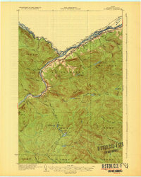
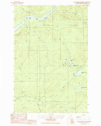
(15)- 1930 Map of Allagash
 1930 Allagash1930 Print · USGSThe northern Maine frontier at the turn of the 1930s was a landscape of remote river settlements and deep woods. Genealogists and historians can trace family locations along the St John River at Dickey, and find community landmarks like St Paul Ch and Henderson Sch.4 unique versions available
 - 1930 Map of St Francis
 1930 St Francis1930 Print · USGSThe Maine-Canada borderland comes alive in the early thirties as a hub of rail-and-river activity along the St John River. Genealogists and researchers can trace family lands near St Francis, local schoolhouses like Harding Sch, and logging sites like Saucier Camp.5 unique versions available
 - 1933 Map of Allagash
 1933 Allagash1933 Print · USGSThe northern Maine borderlands come alive in this early 1930s survey of the river confluences near Dickey. Genealogists and historians can trace the locations of the Log Cabin Sch, Kelly Sch, and landings like Boat Landing Camp along the wild rapids of the Allagash River.3 unique versions available
 - 1933 Map of St Francis
 1933 St Francis1933 Print · USGSThe northern reaches of Aroostook County are captured here in the 1930s, showing the border settlements along the St John River. Genealogists and local historians can trace family locations near St Francis, the Bangor and Aroostook rail line, and the McKinley Sch.3 unique versions available
 - 1962 Map of Edmundston, 1966 Print
 1962 Edmundston1966 Print · USGSThe international borderlands of northern Maine and Canada come alive here during the early sixties, centered on the river-and-rail economies of the day. Genealogists and historians can trace the paths of the Bangor and Aroostook railroad through river towns like Fort Kent and St Agatha.2 unique versions available
 - 1975 Map of St Francis SW, 1981 Print
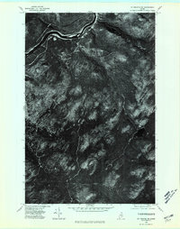 1975 St Francis SW1981 Print · USGSThe deep Maine woods of Aroostook County appear in high-resolution aerial detail during the mid-seventies, showing a landscape shaped by the timber industry. Researchers can trace remote logging roads and waterways like Negro Brook and Jones Mill.
 - 1975 Map of St Francis NW, 1981 Print
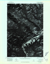 1975 St Francis NW1981 Print · USGSThe northern Maine borderlands come into sharp focus in the mid-seventies, showing the rugged intersection of the river and the forest. Trace the settlement of St Francis along the St. John River where the border meets New Brunswick.
 - 1985 Map of St. Francis, 1986 Print
 1985 St. Francis1986 Print · USGSThe northern Maine borderlands near the mid-1980s are defined here by the meeting of the St John River and the St Francis River. Genealogists and local historians can trace the settlement at St Francis, locate the riverfront Cem, and follow the old Railroad grade through Rankin.
 - 1985 Map of Pelletier Brook Lakes, 1986 Print
 1985 Pelletier Brook Lakes1986 Print · USGSThe St John River valley and the Pelletier Brook drainage are captured in the mid-1980s during a period of active timber management. Researchers can trace remote landmarks like Cross Rock, the river Ford, and the series of Pelletier Brook Lakes.
 - 1986 Map of Big Rapids, 1987 Print
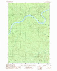 1986 Big Rapids1987 Print · USGSThe North Maine Woods in the mid-eighties reveal a landscape of timberlands and river navigation along the St John River. Outdoorsmen and researchers can trace the river's course through Big Rapids and locate isolated landmarks like the Clay Pit and Poplar Island.
 - 1986 Map of Allagash, 1987 Print
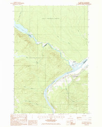
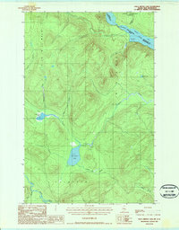
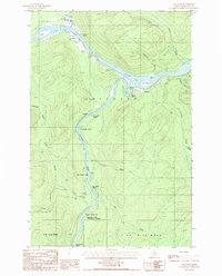 1986 Allagash1987 Print · USGSNorthern Maine's remote river country comes into focus in the mid-1980s at the confluence of two legendary waterways. Trace the riverside settlements of Allagash and Dickey, or locate wilderness landmarks like Ghost Landing Bar and Eliza Hole Rapids.
 - 1987 Map of Johnson Brook Mountain
 1987 Johnson Brook Mountain1987 Print · USGSThe Aroostook County wilderness in the late eighties remained a landscape of timberlands and winding waterways. Follow the Little Black River past Boat Landing Camp and through the heights of Johnson Brook Mountain and Kelly Brook Mountain.
 - 1987 Map of Falls Brook Lake
 1987 Falls Brook Lake1987 Print · USGSThe international border along the St Francis River is captured in the late 1980s, documenting a remote stretch of the North Woods. Researchers can trace timber-access routes and isolated landmarks like Falls Brook Lake, Glazier Lake, and the Gravel Pit.
 - 1993 Map of Allagash, 1994 Print
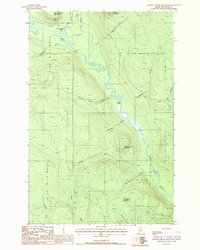
 1993 Allagash1994 Print · USGSThe Maine-Quebec borderlands in the early nineties show a landscape of deep timber and international riverways. Researchers can trace the remote settlements of Allagash and Dickey or locate historic river features like Castonia Rapids and Beau Lake.
 - 1994 Map of Madawaska
 1994 Madawaska1994 Print · USGSThe St John Valley in the 1990s remained a unique cultural crossroads of Maine and New Brunswick, centered on the river and the rails. Genealogists and historians can trace family-named settlements like Violette Settlement or explore the shores of Eagle Lake and Long Lake.
End of results
Showing maps 1-15 of 15
Top cities near Allagash
Top neighborhoods of Allagash
Frequently asked questions
- What are the different types of historical maps available for Allagash?
- What is the oldest map of Allagash?
- Where can I purchase historical maps of Allagash for my home or office?
- Where can I download high-res historical maps of Allagash?
- Are there historical topographic maps available for Allagash?
- Is there historical aerial imagery available for Allagash?
- Where are historical maps of Allagash sourced from?