1930s Maps of Allagash, Maine
Explore 4 historic maps of Allagash from the 1930s. These maps offer a rare glimpse into what life looked like during the 1930s — showing old roads, neighborhoods, homes, and landmarks that have changed or disappeared over time.
Whether you're researching your family's past, planning a metal detecting trip, or studying how Allagash's landscape evolved across the 1930s, these high-resolution maps are a powerful tool for exploring the history of this region.
- Focus on a specific era: All maps on this page are from the 1930s, giving you a focused view of this time period.
- See what’s changed: Compare century-old streets, trails, and buildings to today's modern landscape using overlays and satellite layers.
- Research with precision: Use these maps for genealogy, historical research, land use analysis, or educational projects.
- View, download, or print: Maps are fully viewable online in high resolution, and can be downloaded or printed for your own records.
Start exploring Allagash's history through authentic maps from the 1930s. This is your window into the past.
Allagash, ME maps
(4)- 1930 Map of Allagash
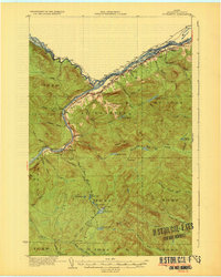
 1930 Allagash1930 Print · USGSThe northern Maine frontier at the turn of the 1930s was a landscape of remote river settlements and deep woods. Genealogists and historians can trace family locations along the St John River at Dickey, and find community landmarks like St Paul Ch and Henderson Sch.4 unique versions available
 - 1930 Map of St Francis
 1930 St Francis1930 Print · USGSThe Maine-Canada borderland comes alive in the early thirties as a hub of rail-and-river activity along the St John River. Genealogists and researchers can trace family lands near St Francis, local schoolhouses like Harding Sch, and logging sites like Saucier Camp.5 unique versions available
 - 1933 Map of Allagash
 1933 Allagash1933 Print · USGSThe northern Maine borderlands come alive in this early 1930s survey of the river confluences near Dickey. Genealogists and historians can trace the locations of the Log Cabin Sch, Kelly Sch, and landings like Boat Landing Camp along the wild rapids of the Allagash River.3 unique versions available
 - 1933 Map of St Francis
 1933 St Francis1933 Print · USGSThe northern reaches of Aroostook County are captured here in the 1930s, showing the border settlements along the St John River. Genealogists and local historians can trace family locations near St Francis, the Bangor and Aroostook rail line, and the McKinley Sch.3 unique versions available
End of results
Showing maps 1-4 of 4
Top cities near Allagash
Top neighborhoods of Allagash
Frequently asked questions
- What are the different types of historical maps available for Allagash?
- What is the oldest map of Allagash?
- Where can I purchase historical maps of Allagash for my home or office?
- Where can I download high-res historical maps of Allagash?
- Are there historical topographic maps available for Allagash?
- Is there historical aerial imagery available for Allagash?
- Where are historical maps of Allagash sourced from?