1970s Maps of Amity, Maine
Explore 4 historic maps of Amity from the 1970s. These maps offer a rare glimpse into what life looked like during the 1970s — showing old roads, neighborhoods, homes, and landmarks that have changed or disappeared over time.
Whether you're researching your family's past, planning a metal detecting trip, or studying how Amity's landscape evolved across the 1970s, these high-resolution maps are a powerful tool for exploring the history of this region.
- Focus on a specific era: All maps on this page are from the 1970s, giving you a focused view of this time period.
- See what’s changed: Compare century-old streets, trails, and buildings to today's modern landscape using overlays and satellite layers.
- Research with precision: Use these maps for genealogy, historical research, land use analysis, or educational projects.
- View, download, or print: Maps are fully viewable online in high resolution, and can be downloaded or printed for your own records.
Start exploring Amity's history through authentic maps from the 1970s. This is your window into the past.
Amity, ME maps
(4)- 1975 Map of Amity SE, 1980 Print
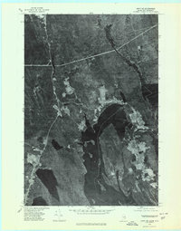 1975 Amity SE1980 Print · USGSThe Maine and New Brunswick border comes into focus in the mid-1970s, showcasing the remote timberlands and waterways along the international line. Trace the small settlements of Orient and Fosterville flanking the deep Chiputneticook Lakes.2 unique versions available
 - 1975 Map of Amity SW, 1980 Print
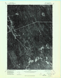 1975 Amity SW1980 Print · USGSAroostook County timberlands are seen in detail during the 1970s, as logging roads and river bends define the landscape. Researchers can trace the clearings of small settlements like Haynesville and North Bancroft along the winding Mattawamkeag River.
 - 1975 Map of Amity NW, 1980 Print
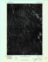 1975 Amity NW1980 Print · USGSAroostook County's deep timberlands are captured in this mid-seventies aerial survey, showing the isolated pockets of Maine's backwoods life. Researchers can trace rural property lines and clearings at Wilcox Settlement and Estabrook Settlement or locate Elevenmile Lake.
 - 1975 Map of Amity NE, 1980 Print
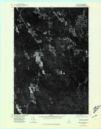 1975 Amity NE1980 Print · USGSThe Maine borderlands near the mid-seventies come into sharp focus in this aerial survey. Genealogists and researchers can trace the cleared fields and forest tracks surrounding North Amity or follow the international line along Monument Stream.
End of results
Showing maps 1-4 of 4
Top cities near Amity
- Houlton historical maps
- Hodgdon historical maps
- Linneus historical maps
- Oakfield historical maps
- New Limerick historical maps
- Smyrna historical maps
See more
Top neighborhoods of Amity
Frequently asked questions
- What are the different types of historical maps available for Amity?
- What is the oldest map of Amity?
- Where can I purchase historical maps of Amity for my home or office?
- Where can I download high-res historical maps of Amity?
- Are there historical topographic maps available for Amity?
- Is there historical aerial imagery available for Amity?
- Where are historical maps of Amity sourced from?