1980s Maps of Cyr Plantation, Maine
Explore 4 historic maps of Cyr Plantation from the 1980s. These maps offer a rare glimpse into what life looked like during the 1980s — showing old roads, neighborhoods, homes, and landmarks that have changed or disappeared over time.
Whether you're researching your family's past, planning a metal detecting trip, or studying how Cyr Plantation's landscape evolved across the 1980s, these high-resolution maps are a powerful tool for exploring the history of this region.
- Focus on a specific era: All maps on this page are from the 1980s, giving you a focused view of this time period.
- See what’s changed: Compare century-old streets, trails, and buildings to today's modern landscape using overlays and satellite layers.
- Research with precision: Use these maps for genealogy, historical research, land use analysis, or educational projects.
- View, download, or print: Maps are fully viewable online in high resolution, and can be downloaded or printed for your own records.
Start exploring Cyr Plantation's history through authentic maps from the 1980s. This is your window into the past.
Cyr Plantation, ME maps
(4)- 1986 Map of Picard Brook
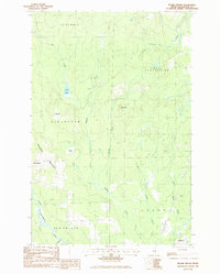 1986 Picard Brook1986 Print · USGSNorthern Maine timberlands and Swedish immigrant settlements define the area in the mid-eighties. Genealogists can trace family footprints near Stockholm, California, and the waterways of the Little Madawaska River.
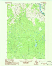
 - 1986 Map of Violette Stream
 1986 Violette Stream1986 Print · USGSThe international border along the St John River comes into focus in the mid-1980s, documenting the remote woods of Aroostook County. Researchers can trace the path of the Old RR Grade and find early boundary markers for Cyr Plantation and Sainte-Anne-de-Madawaska.
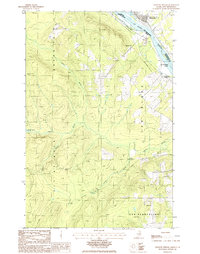
 - 1986 Map of Doyle Ridge
 1986 Doyle Ridge1986 Print · USGSThe Maine-New Brunswick border comes into focus in the mid-1980s along the winding St John River. Researchers can trace the boundaries of Cyr Plantation and find local landmarks like Bellefleur, Dubay Lake, and the U S Military Res.
 - 1986 Map of Van Buren
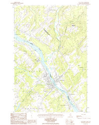 1986 Van Buren1986 Print · USGSThe St. John River borderlands in the mid-1980s reveal a landscape of international commerce and Acadian settlement. Genealogists and historians can trace family locations through Van Buren and Saint-Léonard, or locate landmarks like the Drive-In Theater and Harrison Brook Settlement.
End of results
Showing maps 1-4 of 4
Top cities near Cyr Plantation
- Caribou historical maps
- Fort Fairfield historical maps
- Madawaska historical maps
- Van Buren historical maps
- Limestone historical maps
- Woodland historical maps
See more
Frequently asked questions
- What are the different types of historical maps available for Cyr Plantation?
- What is the oldest map of Cyr Plantation?
- Where can I purchase historical maps of Cyr Plantation for my home or office?
- Where can I download high-res historical maps of Cyr Plantation?
- Are there historical topographic maps available for Cyr Plantation?
- Is there historical aerial imagery available for Cyr Plantation?
- Where are historical maps of Cyr Plantation sourced from?