1990s Maps of E Township, Maine
Explore 4 historic maps of E Township from the 1990s. These maps offer a rare glimpse into what life looked like during the 1990s — showing old roads, neighborhoods, homes, and landmarks that have changed or disappeared over time.
Whether you're researching your family's past, planning a metal detecting trip, or studying how E Township's landscape evolved across the 1990s, these high-resolution maps are a powerful tool for exploring the history of this region.
- Focus on a specific era: All maps on this page are from the 1990s, giving you a focused view of this time period.
- See what’s changed: Compare century-old streets, trails, and buildings to today's modern landscape using overlays and satellite layers.
- Research with precision: Use these maps for genealogy, historical research, land use analysis, or educational projects.
- View, download, or print: Maps are fully viewable online in high resolution, and can be downloaded or printed for your own records.
Start exploring E Township's history through authentic maps from the 1990s. This is your window into the past.
E Township, ME maps
(4)- 1993 Map of Houlton
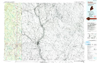 1993 Houlton1993 Print · USGSThe Maine-New Brunswick borderlands are captured here in the early 1990s, centered on the transit and trade hub of Houlton. Genealogists and historians can trace family-named locales and crossroads like Porter Settlement, Jackson Settlement, and Bridgewater Corner.
 - 1993 Map of Fort Fairfield
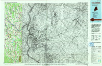 1993 Fort Fairfield1993 Print · USGSThe Aroostook River valley is shown at a pivotal moment in the 1990s as it spans the international border between Maine and New Brunswick. Genealogists and local historians can trace the extent of Loring Air Force Base or locate rural crossroads like Grimes Mill and Sawyer Corner.
 - 1994 Map of Presque Isle
 1994 Presque Isle1994 Print · USGSAroostook County in the mid-nineties shows a landscape defined by timber, rail, and river-valley farming. Genealogists and historians can trace the Bangor & Aroostook RR through small stations and settlements like Winterville Sta, Buffalo, and Sheridan.
 - 1994 Map of Oakfield
 1994 Oakfield1994 Print · USGSAroostook County's North Woods and rural settlements are shown here in the mid-1990s, capturing the region's transition from forest to farmland. Trace the path of the Bangor and Aroostook RR through Smyrna Mills or locate landings on Millinocket Lake.
End of results
Showing maps 1-4 of 4
Top cities near E Township
- Presque Isle historical maps
- Fort Fairfield historical maps
- Mapleton historical maps
- Mars Hill historical maps
- Easton historical maps
- Littleton historical maps
See more
Frequently asked questions
- What are the different types of historical maps available for E Township?
- What is the oldest map of E Township?
- Where can I purchase historical maps of E Township for my home or office?
- Where can I download high-res historical maps of E Township?
- Are there historical topographic maps available for E Township?
- Is there historical aerial imagery available for E Township?
- Where are historical maps of E Township sourced from?