1930s Maps of Fort Kent, Maine
Explore 6 historic maps of Fort Kent from the 1930s. These maps offer a rare glimpse into what life looked like during the 1930s — showing old roads, neighborhoods, homes, and landmarks that have changed or disappeared over time.
Whether you're researching your family's past, planning a metal detecting trip, or studying how Fort Kent's landscape evolved across the 1930s, these high-resolution maps are a powerful tool for exploring the history of this region.
- Focus on a specific era: All maps on this page are from the 1930s, giving you a focused view of this time period.
- See what’s changed: Compare century-old streets, trails, and buildings to today's modern landscape using overlays and satellite layers.
- Research with precision: Use these maps for genealogy, historical research, land use analysis, or educational projects.
- View, download, or print: Maps are fully viewable online in high resolution, and can be downloaded or printed for your own records.
Start exploring Fort Kent's history through authentic maps from the 1930s. This is your window into the past.
Fort Kent, ME maps
(6)- 1931 Map of Square Lake
 1931 Square Lake1931 Print · USGSAroostook County's lake country in the early 1930s shows a landscape of timber camps and small rural settlements. Genealogists and historians can trace schools like Guerrette Sch and Thomas Sch or locate family-named landmarks like Ouellette and Yerxa Camp.4 unique versions available
 - 1931 Map of Eagle Lake
 1931 Eagle Lake1931 Print · USGSThe Aroostook County borderlands in the early thirties were a landscape of remote timber camps and French-Acadian settlements along the river bends. Genealogists and local historians can trace family-named sites like Violette Settlement, Labby Michaud PO, and the Plourde Mill.4 unique versions available
 - 1932 Map of Frenchville
 1932 Frenchville1932 Print · USGSAroostook County's international borderland and rail network are meticulously detailed in the early 1930s, showing the intersection of Maine and New Brunswick. Genealogists can trace numerous local landmarks including St David Ch, Dionne Corner, and a series of numbered rural schools like School No 15.2 unique versions available
 - 1932 Map of Fort Kent
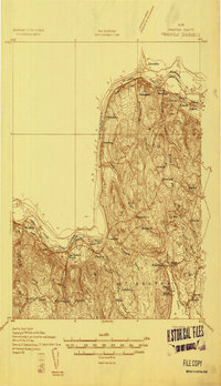
 1932 Fort Kent1932 Print · USGSThe northern reaches of the Maine border are captured here during the 1930s, centering on the international river crossing at Fort Kent. Genealogists and historians can trace rail and road networks including the Bangor and Aroostook Main Line and the settlement at Daigle.4 unique versions available
 - 1935 Map of Fort Kent
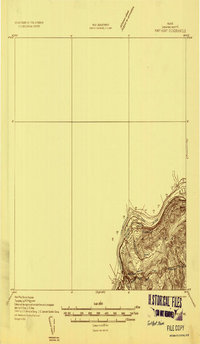
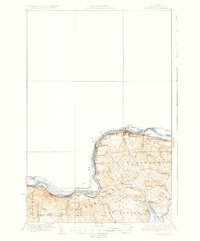
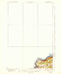 1935 Fort Kent1935 Print · USGSFort Kent and the northern Maine borderlands are captured here in the mid-1930s along the winding St John River. Genealogists and local historians can trace the specific locations of early 20th-century rural schools like Roosevelt Sch and Hillside Sch near the town of Fort Kent.3 unique versions available
 - 1935 Map of Frenchville
 1935 Frenchville1935 Print · USGSUpper Aroostook County during the mid-1930s reveals a landscape shaped by the St. John River and the timber-and-farm economy. Researchers can trace the legacy of rural education and rail sidings through landmarks like Lincoln Sch, Pelletier Siding, and Dionne Corner.4 unique versions available
End of results
Showing maps 1-6 of 6
Top cities near Fort Kent
- Madawaska historical maps
- Frenchville historical maps
- Eagle Lake historical maps
- Saint Agatha historical maps
- Square Lake historical maps
- Wallagrass historical maps
See more
Top neighborhoods of Fort Kent
- Fort Kent Mills historical maps
- Monument Square historical maps
- Pierre historical maps
- Violette Settlement historical maps
- Fort Kent Village historical maps
- Kent Junction historical maps
See more
Frequently asked questions
- What are the different types of historical maps available for Fort Kent?
- What is the oldest map of Fort Kent?
- Where can I purchase historical maps of Fort Kent for my home or office?
- Where can I download high-res historical maps of Fort Kent?
- Are there historical topographic maps available for Fort Kent?
- Is there historical aerial imagery available for Fort Kent?
- Where are historical maps of Fort Kent sourced from?