1900s (20th Century) Maps of Monument Square, Fort Kent
Explore 6 historic maps of Monument Square from the 1900s (20th Century). These maps offer a rare glimpse into what life looked like during the 1900s — showing old roads, neighborhoods, homes, and landmarks that have changed or disappeared over time.
Whether you're researching your family's past, planning a metal detecting trip, or studying how Monument Square's landscape evolved across the 1900s, these high-resolution maps are a powerful tool for exploring the history of this region.
- Focus on a specific era: All maps on this page are from the 1900s, giving you a focused view of this time period.
- See what’s changed: Compare century-old streets, trails, and buildings to today's modern landscape using overlays and satellite layers.
- Research with precision: Use these maps for genealogy, historical research, land use analysis, or educational projects.
- View, download, or print: Maps are fully viewable online in high resolution, and can be downloaded or printed for your own records.
Start exploring Monument Square's history through authentic maps from the 1900s. This is your window into the past.
Monument Square, Fort Kent maps
(6)- 1932 Map of Fort Kent
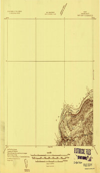 1932 Fort Kent1932 Print · USGSThe northern reaches of the Maine border are captured here during the 1930s, centering on the international river crossing at Fort Kent. Genealogists and historians can trace rail and road networks including the Bangor and Aroostook Main Line and the settlement at Daigle.4 unique versions available
 - 1935 Map of Fort Kent
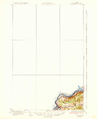 1935 Fort Kent1935 Print · USGSFort Kent and the northern Maine borderlands are captured here in the mid-1930s along the winding St John River. Genealogists and local historians can trace the specific locations of early 20th-century rural schools like Roosevelt Sch and Hillside Sch near the town of Fort Kent.3 unique versions available
 - 1962 Map of Edmundston, 1966 Print
 1962 Edmundston1966 Print · USGSThe international borderlands of northern Maine and Canada come alive here during the early sixties, centered on the river-and-rail economies of the day. Genealogists and historians can trace the paths of the Bangor and Aroostook railroad through river towns like Fort Kent and St Agatha.2 unique versions available
 - 1975 Map of Fort Kent SE, 1981 Print
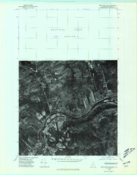 1975 Fort Kent SE1981 Print · USGSThe international border along the St John River is captured here in the mid-seventies, showing the interconnected river valley communities. Local historians and genealogists can trace the homesteads and farms surrounding Fort Kent, Clair, and Baker Brook.
 - 1985 Map of Fort Kent North, 1986 Print
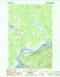 1985 Fort Kent North1986 Print · USGSThis mid-1980s survey of the Maine-New Brunswick border captures the riverfront landscape where Fort Kent and Clair meet. Researchers can trace land divisions at Rang-Saint-Joseph, find the Public Boat Ramp, and locate islands like Turtle Island.
 - 1994 Map of Madawaska
 1994 Madawaska1994 Print · USGSThe St John Valley in the 1990s remained a unique cultural crossroads of Maine and New Brunswick, centered on the river and the rails. Genealogists and historians can trace family-named settlements like Violette Settlement or explore the shores of Eagle Lake and Long Lake.
End of results
Showing maps 1-6 of 6
Frequently asked questions
- What are the different types of historical maps available for Monument Square?
- What is the oldest map of Monument Square?
- Where can I purchase historical maps of Monument Square for my home or office?
- Where can I download high-res historical maps of Monument Square?
- Are there historical topographic maps available for Monument Square?
- Is there historical aerial imagery available for Monument Square?
- Where are historical maps of Monument Square sourced from?