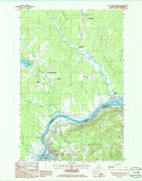
1985 Map of Fort Kent North
USGS Topo · Published 1986About this map
The St John River defines the international boundary between Maine and New Brunswick on this 1980s-era survey, where the town of Fort Kent serves as a critical point of entry and commerce. The confluence of the Fish River and the larger waterway anchors the settlement pattern, which is characterized by traditional Acadian-style long lots visible in the surrounding rural concessions. To the north, the landscape rises toward Grande Montagne, while smaller hamlets like Soucy and Baker dot the upland terrain. Local infrastructure of the mid-1980s is clearly delineated, including the Public Boat Ramp and Gravel Pits near the riverbank. This map captures the region's unique geography, where water bodies like Lac Caron and Lac a Eugene are connected by a network of seasonal brooks and local routes like 161 and 120, reflecting the cross-border connectivity of the Upper Saint John River Valley.
Find a feature on this map
45 named features on this map. Tap any name to fly to it.
Don’t see what you’re looking for? This feature index may not catch every label — zoom into the map to look around manually.
Map Details
Editions of this 1985 Fort Kent North Map
This is the sole edition of this map. No revisions or reprints were ever made.
Other maps of this area

1927 · Square Lake
USGS Topo · 1:48,000

1928 · Eagle Lake
USGS Topo · 1:48,000

1931 · Square Lake
USGS Topo · 1:62,500

1931 · Eagle Lake
USGS Topo · 1:62,500

1932 · Frenchville
USGS Topo · 1:48,000

1932 · Fort Kent
USGS Topo · 1:48,000

1935 · Fort Kent
USGS Topo · 1:62,500

1935 · Frenchville
USGS Topo · 1:62,500

1953 · Square Lake
USGS Topo · 1:62,500

1962 · Edmundston
USGS Topo · 1:250,000