
1927 Map of Square Lake
USGS Topo · Published 1927About this map
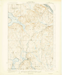
The waters of the northern Maine woods dominate this 1927 survey, centered on the expansive Square Lake and its connection to Cross Lake and Eagle Lake. This area of Aroostook County shows a landscape defined by traditional industry and early settlement patterns, where timber and small-scale agriculture supported communities like St Agatha and Daigle. A network of numbered rural schools, from No 3 School near Long Lake to No 11 School in the northern hills, illustrates the decentralized nature of education for farming families during the interwar period.
Find a feature on this map
80 named features on this map. Tap any name to fly to it.
Don’t see what you’re looking for? This feature index may not catch every label — zoom into the map to look around manually.
Map Details
Editions of this 1927 Square Lake Map
This is the sole edition of this map. No revisions or reprints were ever made.
Other maps of this area

1927 · Stockholm
USGS Topo · 1:48,000

1928 · Eagle Lake
USGS Topo · 1:48,000

1928 · Winterville
USGS Topo · 1:48,000

1929 · Portage
USGS Topo · 1:62,500

1929 · Caribou
USGS Topo · 1:48,000

1931 · Square Lake
USGS Topo · 1:62,500

1931 · Eagle Lake
USGS Topo · 1:62,500

1931 · Portage
USGS Topo · 1:62,500
1931 · Stockholm
USGS Topo · 1:62,500

1931 · Winterville
USGS Topo · 1:62,500