1980s Maps of Island Falls, Maine
Explore 6 historic maps of Island Falls from the 1980s. These maps offer a rare glimpse into what life looked like during the 1980s — showing old roads, neighborhoods, homes, and landmarks that have changed or disappeared over time.
Whether you're researching your family's past, planning a metal detecting trip, or studying how Island Falls's landscape evolved across the 1980s, these high-resolution maps are a powerful tool for exploring the history of this region.
- Focus on a specific era: All maps on this page are from the 1980s, giving you a focused view of this time period.
- See what’s changed: Compare century-old streets, trails, and buildings to today's modern landscape using overlays and satellite layers.
- Research with precision: Use these maps for genealogy, historical research, land use analysis, or educational projects.
- View, download, or print: Maps are fully viewable online in high resolution, and can be downloaded or printed for your own records.
Start exploring Island Falls's history through authentic maps from the 1980s. This is your window into the past.
Island Falls, ME maps
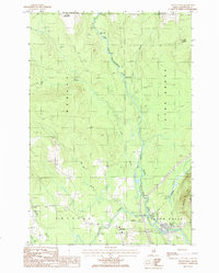
(6)- 1985 Map of Oakfield
 1985 Oakfield1985 Print · USGSAroostook County in the 1980s displays a balance between the timber-and-rail industry and the protected wilderness of the North Woods. Genealogists and local historians can trace family-named hubs like Smyrna Mills, Island Falls, and Knowles Corner along the Bangor and Aroostook railroad line.
 - 1985 Map of Millinocket, 1986 Print
 1985 Millinocket1986 Print · USGSThe North Maine Woods were a landscape of industrial timber and wilderness recreation in the mid-eighties. Genealogists and researchers can trace local settlements and rail stops like Sherman Mills, Wytopitlock, and the Old Long A Siding near the Penobscot River.2 unique versions available
 - 1986 Map of Oakfield
 1986 Oakfield1986 Print · USGSOakfield and its surrounding timberlands are captured here in the mid-eighties, showing a landscape defined by the railroad and the river. Genealogists and historians can trace the Walker Settlement, the rail yards of Oakfield, and lakeside landmarks like Birch Point.
 - 1986 Map of Island Falls
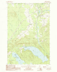
 1986 Island Falls1986 Print · USGSIn the mid-eighties, this portion of Southern Aroostook County centered on the junction of the West Branch Mattawamkeag River and the Bangor and Aroostook railroad. Genealogists and historians can trace the layouts of Island Falls, Batesville, and Belvedere alongside local landmarks like the Cem and Robinson Mtn.
 - 1989 Map of Crystal
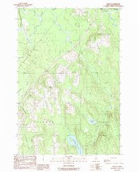 1989 Crystal1989 Print · USGSAroostook County's southern timber and bog lands are captured here in the late eighties as the region's rural character endured. Genealogists and historians can locate the Cem at Crystal, the homes at Golden Ridge, and the waters of Macwahoc Lake.
 - 1989 Map of Mattawamkeag Lake
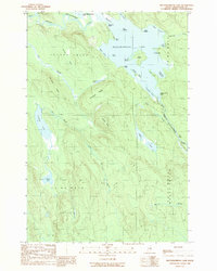 1989 Mattawamkeag Lake1989 Print · USGSAroostook County's lake country is captured here in the late twentieth century, showing the interconnected waters of the Mattawamkeag system. Genealogists and historians can trace family-named landmarks like Hamiltons Mistake, Bible Point, and the boundaries of Island Falls.
End of results
Showing maps 1-6 of 6
Top cities near Island Falls
- Linneus historical maps
- Patten historical maps
- Sherman historical maps
- Oakfield historical maps
- New Limerick historical maps
- Smyrna historical maps
See more
Top neighborhoods of Island Falls
Frequently asked questions
- What are the different types of historical maps available for Island Falls?
- What is the oldest map of Island Falls?
- Where can I purchase historical maps of Island Falls for my home or office?
- Where can I download high-res historical maps of Island Falls?
- Are there historical topographic maps available for Island Falls?
- Is there historical aerial imagery available for Island Falls?
- Where are historical maps of Island Falls sourced from?