1980s Maps of Perham, Maine
Explore 4 historic maps of Perham from the 1980s. These maps offer a rare glimpse into what life looked like during the 1980s — showing old roads, neighborhoods, homes, and landmarks that have changed or disappeared over time.
Whether you're researching your family's past, planning a metal detecting trip, or studying how Perham's landscape evolved across the 1980s, these high-resolution maps are a powerful tool for exploring the history of this region.
- Focus on a specific era: All maps on this page are from the 1980s, giving you a focused view of this time period.
- See what’s changed: Compare century-old streets, trails, and buildings to today's modern landscape using overlays and satellite layers.
- Research with precision: Use these maps for genealogy, historical research, land use analysis, or educational projects.
- View, download, or print: Maps are fully viewable online in high resolution, and can be downloaded or printed for your own records.
Start exploring Perham's history through authentic maps from the 1980s. This is your window into the past.
Perham, ME maps
(4)- 1984 Map of Washburn, 1985 Print
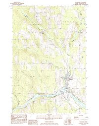 1984 Washburn1985 Print · USGSAroostook County agriculture and river life are on display here in the mid-1980s, centered on the village of Washburn. Trace the legacy of the Bangor and Aroostook rail line through rural outposts like Perham, Bugbee, and North Wade.
 - 1985 Map of Mud Lake
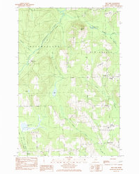 1985 Mud Lake1985 Print · USGSIn the mid-1980s, the agricultural and timber lands of Aroostook County remained centered on small township hubs and rail corridors. Genealogists can locate family landmarks like Woodland Center, the Jemtland Cem, and the New Sweden Consolidated Sch.
 - 1986 Map of Bull Brook
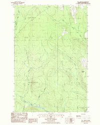 1986 Bull Brook1986 Print · USGSNorthern Maine's timberlands are captured in the mid-1980s, showing the remote township lines of Wade and Perham. Genealogists and historians can locate isolated sites like Thompson Camp, Drost Camp, and the Lookout Tower on Story Hill.
 - 1986 Map of Hanford
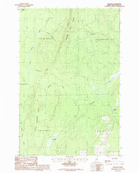 1986 Hanford1986 Print · USGSNorthern Aroostook County during the mid-1980s reveals a landscape of high timber ridges and winding waterways at the edge of the deep woods. Trace the local topography through Square Lake Ridge, the settlement at Hanford, and family-named features like Joe Dubay Bk.
End of results
Showing maps 1-4 of 4
Top cities near Perham
- Presque Isle historical maps
- Caribou historical maps
- Mapleton historical maps
- Washburn historical maps
- Woodland historical maps
- Ashland historical maps
See more
Top neighborhoods of Perham
Frequently asked questions
- What are the different types of historical maps available for Perham?
- What is the oldest map of Perham?
- Where can I purchase historical maps of Perham for my home or office?
- Where can I download high-res historical maps of Perham?
- Are there historical topographic maps available for Perham?
- Is there historical aerial imagery available for Perham?
- Where are historical maps of Perham sourced from?