1970s Maps of Perham, Maine
Explore 4 historic maps of Perham from the 1970s. These maps offer a rare glimpse into what life looked like during the 1970s — showing old roads, neighborhoods, homes, and landmarks that have changed or disappeared over time.
Whether you're researching your family's past, planning a metal detecting trip, or studying how Perham's landscape evolved across the 1970s, these high-resolution maps are a powerful tool for exploring the history of this region.
- Focus on a specific era: All maps on this page are from the 1970s, giving you a focused view of this time period.
- See what’s changed: Compare century-old streets, trails, and buildings to today's modern landscape using overlays and satellite layers.
- Research with precision: Use these maps for genealogy, historical research, land use analysis, or educational projects.
- View, download, or print: Maps are fully viewable online in high resolution, and can be downloaded or printed for your own records.
Start exploring Perham's history through authentic maps from the 1970s. This is your window into the past.
Perham, ME maps
(4)- 1975 Map of Caribou NW, 1981 Print
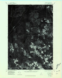 1975 Caribou NW1981 Print · USGSAroostook County's landscape in the mid-seventies is captured in this aerial survey of the rural communities and forestlands northwest of Caribou. Genealogists and local historians can trace field lines and farmsteads near Sweden, Colby, and Woodland Center.
 - 1975 Map of Portage NE, 1981 Print
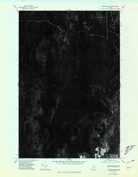 1975 Portage NE1981 Print · USGSNorthern Maine's timberlands are seen in detail during the mid-seventies, documenting the isolated settlement patterns of the deep woods. Researchers can trace forest roads and the small community at Hanford.
 - 1975 Map of Portage SE, 1981 Print
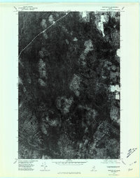 1975 Portage SE1981 Print · USGSAroostook County was deeply immersed in timber production during the 1970s, as shown in this detailed orthophotomap. Researchers can trace the path of Beaver Brook through the dense forest canopy and identify old logging roads and clearings.
 - 1975 Map of Caribou SW, 1981 Print
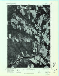 1975 Caribou SW1981 Print · USGSAroostook County agriculture and river life are captured in this mid-seventies aerial survey of the Maine countryside. Genealogists and local historians can trace the layouts of Washburn and Bugbee or follow the banks of the Aroostook River.
End of results
Showing maps 1-4 of 4
Top cities near Perham
- Presque Isle historical maps
- Caribou historical maps
- Mapleton historical maps
- Washburn historical maps
- Woodland historical maps
- Ashland historical maps
See more
Top neighborhoods of Perham
Frequently asked questions
- What are the different types of historical maps available for Perham?
- What is the oldest map of Perham?
- Where can I purchase historical maps of Perham for my home or office?
- Where can I download high-res historical maps of Perham?
- Are there historical topographic maps available for Perham?
- Is there historical aerial imagery available for Perham?
- Where are historical maps of Perham sourced from?