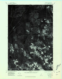
1975 Map of Caribou NW
USGS Topo · Published 1981About this map
Sweden and Colby occupy the eastern portion of this 1975 orthophotoquad, revealing the agricultural and forest patterns of Aroostook County during the mid-1970s. This aerial perspective, prepared from high-altitude photography, provides a clear view of the rural settlement at Woodland Center and the more remote community of Spaulding further west. The landscape is defined by the winding course of the Madawaska River and Caribou Stream, with large tracts of managed woodland interspersed with cleared fields. Researchers can observe the historical land use around Salmon Brook Lake and the drainage of Salmon Brook, capturing the region's character before modern reforestation and development altered these patterns. The orthophoto format offers a unique literal record of the ground surface, showing specific field boundaries and farmsteads as they existed at the time of the flight.
Find a feature on this map
8 named features on this map. Tap any name to fly to it.
Don’t see what you’re looking for? This feature index may not catch every label — zoom into the map to look around manually.
Map Details
Editions of this 1975 Caribou NW Map
This is the sole edition of this map. No revisions or reprints were ever made.
Other maps of this area

1927 · Stockholm
USGS Topo · 1:48,000

1927 · Square Lake
USGS Topo · 1:48,000

1929 · Portage
USGS Topo · 1:62,500

1929 · Caribou
USGS Topo · 1:48,000

1931 · Square Lake
USGS Topo · 1:62,500

1931 · Portage
USGS Topo · 1:62,500

1931 · Stockholm
USGS Topo · 1:62,500

1932 · Caribou
USGS Topo · 1:62,500

1953 · Stockholm
USGS Topo · 1:62,500

1953 · Square Lake
USGS Topo · 1:62,500