1940s Maps of Presque Isle, Maine
Explore 1 historic maps of Presque Isle from the 1940s. These maps offer a rare glimpse into what life looked like during the 1940s — showing old roads, neighborhoods, homes, and landmarks that have changed or disappeared over time.
Whether you're researching your family's past, planning a metal detecting trip, or studying how Presque Isle's landscape evolved across the 1940s, these high-resolution maps are a powerful tool for exploring the history of this region.
- Focus on a specific era: All maps on this page are from the 1940s, giving you a focused view of this time period.
- See what’s changed: Compare century-old streets, trails, and buildings to today's modern landscape using overlays and satellite layers.
- Research with precision: Use these maps for genealogy, historical research, land use analysis, or educational projects.
- View, download, or print: Maps are fully viewable online in high resolution, and can be downloaded or printed for your own records.
Start exploring Presque Isle's history through authentic maps from the 1940s. This is your window into the past.
Presque Isle, ME maps
(1)- 1940 Map of Mars Hill
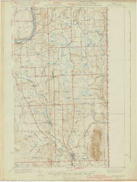 1940 Mars Hill1940 Print · USGSAroostook County was a hub of rail and river commerce in the late 1930s, defined by its connection to the Canadian border. You can trace early schoolhouse locations like Maple Grove Sch and the industrial roots of Monson Mill and Easton Station.3 unique versions available
End of results
Showing maps 1-1 of 1
Top cities near Presque Isle
- Caribou historical maps
- Fort Fairfield historical maps
- Mapleton historical maps
- Washburn historical maps
- Limestone historical maps
- Mars Hill historical maps
See more
Top neighborhoods of Presque Isle
- Sawyer Corner historical maps
- Parkhurst historical maps
- Washburn Junction historical maps
- Rands historical maps
- Campbell historical maps
- Spragueville historical maps
See more
Frequently asked questions
- What are the different types of historical maps available for Presque Isle?
- What is the oldest map of Presque Isle?
- Where can I purchase historical maps of Presque Isle for my home or office?
- Where can I download high-res historical maps of Presque Isle?
- Are there historical topographic maps available for Presque Isle?
- Is there historical aerial imagery available for Presque Isle?
- Where are historical maps of Presque Isle sourced from?