1980s Maps of T11 R10 WELS, Maine
Explore 4 historic maps of T11 R10 WELS from the 1980s. These maps offer a rare glimpse into what life looked like during the 1980s — showing old roads, neighborhoods, homes, and landmarks that have changed or disappeared over time.
Whether you're researching your family's past, planning a metal detecting trip, or studying how T11 R10 WELS's landscape evolved across the 1980s, these high-resolution maps are a powerful tool for exploring the history of this region.
- Focus on a specific era: All maps on this page are from the 1980s, giving you a focused view of this time period.
- See what’s changed: Compare century-old streets, trails, and buildings to today's modern landscape using overlays and satellite layers.
- Research with precision: Use these maps for genealogy, historical research, land use analysis, or educational projects.
- View, download, or print: Maps are fully viewable online in high resolution, and can be downloaded or printed for your own records.
Start exploring T11 R10 WELS's history through authentic maps from the 1980s. This is your window into the past.
T11 R10 WELS, ME maps
(4)- 1985 Map of Farrar Pond, 1986 Print
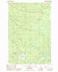 1985 Farrar Pond1986 Print · USGSNorth Woods timberlands in Aroostook County appear here in the mid-eighties as a network of private logging roads and glacial waterways. Researchers can trace remote drainage systems and land use through features like Ketcham Bog, Pratt Lake, and T 11 R 10 Wels (Dry Town).
 - 1985 Map of Mooseleuk Lake, 1986 Print
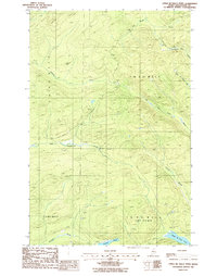
 1985 Mooseleuk Lake1986 Print · USGSNorthern Maine's remote timberlands are captured here in the mid-eighties, centered on the waters of Mooseleuk Lake. Trace back-country landmarks like Shaw Camp, the Horseshoe Lookout Mtn, and the winding McPherson Brook.
 - 1986 Map of Upper Mc Nally Pond
 1986 Upper Mc Nally Pond1986 Print · USGSAroostook County in the mid-1980s was a landscape of commercial timberlands and remote waterways. Researchers can trace resource extraction sites like Shale Pit or follow the paths of Little Musquacook Stream and Upper Mc Nally Pond.
 - 1986 Map of Fifth Musquacook Lake, 1987 Print
 1986 Fifth Musquacook Lake1987 Print · USGSNorthern Maine's remote lake country is documented here in the mid-1980s, spanning the border of Aroostook and Piscataquis counties. Genealogists and researchers can trace the waterways and woods roads around Fifth Musquacook Lake, Peaked Mountain, and Clear Lake.
End of results
Showing maps 1-4 of 4
Frequently asked questions
- What are the different types of historical maps available for T11 R10 WELS?
- What is the oldest map of T11 R10 WELS?
- Where can I purchase historical maps of T11 R10 WELS for my home or office?
- Where can I download high-res historical maps of T11 R10 WELS?
- Are there historical topographic maps available for T11 R10 WELS?
- Is there historical aerial imagery available for T11 R10 WELS?
- Where are historical maps of T11 R10 WELS sourced from?