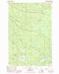
1985 Map of Farrar Pond
USGS Topo · Published 1986About this map
T 11 R 10 Wels (Dry Town) and surrounding unorganized townships in Aroostook County represent the deep timberlands of northern Maine during the mid-1980s. This survey, compiled from 1982 aerial photography, documents a landscape shaped by industrial forestry and the glacial drainage of the North Woods. Water dominates the terrain, from the southern expanse of Pratt Lake and the smaller Farrar Pond to the meandering courses of Twentymile Brook and Twentyfive Mile Brook. A network of unnamed Private Roads provides the primary access through these townships, linking scattered resource extraction sites like the Shale Pit and Gravel Pit. The map captures a specific moment in the land's management, highlighting the interface between remote recreational sites, such as the Campsite near the confluence of the Left Fork and Right Fork, and the commercial utility of the surrounding timber blocks in T 12 R 10 Wels and T 12 R 9 Wels.
Find a feature on this map
19 named features on this map. Tap any name to fly to it.
Don’t see what you’re looking for? This feature index may not catch every label — zoom into the map to look around manually.
Map Details
Editions of this 1985 Farrar Pond Map
This is the sole edition of this map. No revisions or reprints were ever made.
Other maps of this area

1931 · Fish River Lake
USGS Topo · 1:48,000

1931 · Mooseleuk Lake
USGS Topo · 1:48,000

1932 · Musquacook Lakes
USGS Topo · 1:48,000

1932 · Allagash Falls
USGS Topo · 1:48,000

1935 · Musquacook Lakes
USGS Topo · 1:62,500

1935 · Fish River Lake
USGS Topo · 1:62,500

1935 · Mooseleuk Lake
USGS Topo · 1:62,500

1935 · Allagash Falls
USGS Topo · 1:62,500

1954 · Presque Isle
USGS Topo · 1:250,000

1956 · Allagash Falls
USGS Topo · 1:50,000