1970s Maps of T12 R17 WELS, Maine
Explore 3 historic maps of T12 R17 WELS from the 1970s. These maps offer a rare glimpse into what life looked like during the 1970s — showing old roads, neighborhoods, homes, and landmarks that have changed or disappeared over time.
Whether you're researching your family's past, planning a metal detecting trip, or studying how T12 R17 WELS's landscape evolved across the 1970s, these high-resolution maps are a powerful tool for exploring the history of this region.
- Focus on a specific era: All maps on this page are from the 1970s, giving you a focused view of this time period.
- See what’s changed: Compare century-old streets, trails, and buildings to today's modern landscape using overlays and satellite layers.
- Research with precision: Use these maps for genealogy, historical research, land use analysis, or educational projects.
- View, download, or print: Maps are fully viewable online in high resolution, and can be downloaded or printed for your own records.
Start exploring T12 R17 WELS's history through authentic maps from the 1970s. This is your window into the past.
T12 R17 WELS, ME maps
(3)- 1976 Map of Depot Lake, 1983 Print
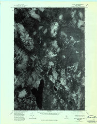 1976 Depot Lake1983 Print · USGSNorthern Maine and Quebec meet in this 1970s orthophotoquad, showing the deep timberlands and waterways along the international border. Trace the remote landscape of Depot Mountain and the winding waters of Cunliffe Pond and Depot Stream.
 - 1977 Map of St. Adalbert, 1983 Print
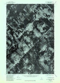 1977 St. Adalbert1983 Print · USGSThe Quebec-Maine borderlands are captured in this late-seventies aerial survey, showing the deep timber country of the North Woods. Researchers can trace the layout of the settlement at St Adalbert and the network of logging roads as they existed decades ago.
 - 1977 Map of Burntland Pond, 1983 Print
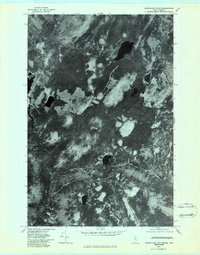 1977 Burntland Pond1983 Print · USGSThe Maine-Quebec borderlands come into sharp focus in the late seventies, showing a landscape defined by industrial timber tracks and the international line at Frontiere. Researchers can trace remote logging routes and water features like Burntland Pond and the Northwest Branch St John River.
End of results
Showing maps 1-3 of 3
Top neighborhoods of T12 R17 WELS
Frequently asked questions
- What are the different types of historical maps available for T12 R17 WELS?
- What is the oldest map of T12 R17 WELS?
- Where can I purchase historical maps of T12 R17 WELS for my home or office?
- Where can I download high-res historical maps of T12 R17 WELS?
- Are there historical topographic maps available for T12 R17 WELS?
- Is there historical aerial imagery available for T12 R17 WELS?
- Where are historical maps of T12 R17 WELS sourced from?