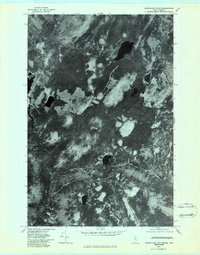
1977 Map of Burntland Pond
USGS Topo · Published 1983About this map
Frontiere marks the international boundary line in this remote northern Maine landscape, where the Maine-Quebec border defines the western edge of the territory. The 1977 aerial imagery reveals a dense forest patchwork heavily influenced by the logging industry, with clearings and access roads surrounding several isolated water bodies. The Northwest Branch St John River meanders through the southern portion of the quadrangle, joined by the waters of Burntland Brook and Depot Stream. These waterways served as the primary transit corridors for timber before the expansion of the modern road network. Significant inland features include Burntland Pond, Beaver Pond, and Bean Pond, each set within a basin of timberland that remains largely undeveloped. This orthophotograph provides a precise visual record of forest management patterns and hydrological features along the Canadian border in the late 1970s.
Find a feature on this map
8 named features on this map. Tap any name to fly to it.
Don’t see what you’re looking for? This feature index may not catch every label — zoom into the map to look around manually.
Map Details
Editions of this 1977 Burntland Pond Map
This is the sole edition of this map. No revisions or reprints were ever made.
Other maps of this area

1954 · Presque Isle
USGS Topo · 1:250,000

1955 · Depot Lake
USGS Topo · 1:62,500

1955 · Beaver Pond
USGS Topo · 1:62,500

1958 · Presque Isle
USGS Topo · 1:250,000

1960 · Presque Isle
USGS Topo · 1:250,000

1962 · Quebec
USGS Topo · 1:250,000

1976 · Depot Lake
USGS Topo · 1:24,000
1977 · St. Adalbert
USGS Topo · 1:24,000
1986 · Mary L Pond
USGS Topo · 1:24,000
1986 · Beaver Pond SE
USGS Topo · 1:24,000