1980s Maps of T18 R11 WELS, Maine
Explore 4 historic maps of T18 R11 WELS from the 1980s. These maps offer a rare glimpse into what life looked like during the 1980s — showing old roads, neighborhoods, homes, and landmarks that have changed or disappeared over time.
Whether you're researching your family's past, planning a metal detecting trip, or studying how T18 R11 WELS's landscape evolved across the 1980s, these high-resolution maps are a powerful tool for exploring the history of this region.
- Focus on a specific era: All maps on this page are from the 1980s, giving you a focused view of this time period.
- See what’s changed: Compare century-old streets, trails, and buildings to today's modern landscape using overlays and satellite layers.
- Research with precision: Use these maps for genealogy, historical research, land use analysis, or educational projects.
- View, download, or print: Maps are fully viewable online in high resolution, and can be downloaded or printed for your own records.
Start exploring T18 R11 WELS's history through authentic maps from the 1980s. This is your window into the past.
T18 R11 WELS, ME maps
(4)- 1987 Map of Beau Lake
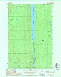 1987 Beau Lake1987 Print · USGSThe northern reaches of the Maine-Canada border are defined by the winding Beau Lake St Francis River in the late eighties. Researchers can trace the wild landscape of the St. John Valley through landmarks like Cross Lake Mountain and Cross Lake Rapids.
 - 1987 Map of Johnson Brook Mountain
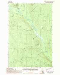 1987 Johnson Brook Mountain1987 Print · USGSThe Aroostook County wilderness in the late eighties remained a landscape of timberlands and winding waterways. Follow the Little Black River past Boat Landing Camp and through the heights of Johnson Brook Mountain and Kelly Brook Mountain.
 - 1987 Map of Hafey Pond
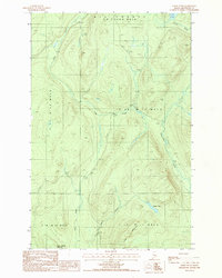 1987 Hafey Pond1987 Print · USGSAroostook County's timberlands are shown in the late twentieth century as a landscape of resource extraction and remote water bodies. Researchers can trace forest access routes and geographic landmarks like Hafey Pond, Boat Landing Mountain, and a local Gravel Pit.
 - 1987 Map of Falls Brook Lake
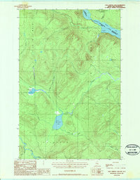 1987 Falls Brook Lake1987 Print · USGSThe international border along the St Francis River is captured in the late 1980s, documenting a remote stretch of the North Woods. Researchers can trace timber-access routes and isolated landmarks like Falls Brook Lake, Glazier Lake, and the Gravel Pit.
End of results
Showing maps 1-4 of 4
Top cities near T18 R11 WELS
Frequently asked questions
- What are the different types of historical maps available for T18 R11 WELS?
- What is the oldest map of T18 R11 WELS?
- Where can I purchase historical maps of T18 R11 WELS for my home or office?
- Where can I download high-res historical maps of T18 R11 WELS?
- Are there historical topographic maps available for T18 R11 WELS?
- Is there historical aerial imagery available for T18 R11 WELS?
- Where are historical maps of T18 R11 WELS sourced from?