1950s Maps of T18 R13 WELS, Maine
Explore 3 historic maps of T18 R13 WELS from the 1950s. These maps offer a rare glimpse into what life looked like during the 1950s — showing old roads, neighborhoods, homes, and landmarks that have changed or disappeared over time.
Whether you're researching your family's past, planning a metal detecting trip, or studying how T18 R13 WELS's landscape evolved across the 1950s, these high-resolution maps are a powerful tool for exploring the history of this region.
- Focus on a specific era: All maps on this page are from the 1950s, giving you a focused view of this time period.
- See what’s changed: Compare century-old streets, trails, and buildings to today's modern landscape using overlays and satellite layers.
- Research with precision: Use these maps for genealogy, historical research, land use analysis, or educational projects.
- View, download, or print: Maps are fully viewable online in high resolution, and can be downloaded or printed for your own records.
Start exploring T18 R13 WELS's history through authentic maps from the 1950s. This is your window into the past.
T18 R13 WELS, ME maps
(3)- 1955 Map of Rocky Mountain
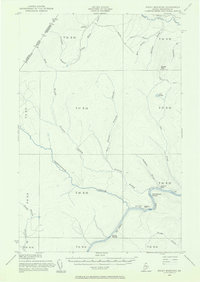 1955 Rocky Mountain1955 Print · USGSThe Aroostook County wilderness in the mid-1950s is defined here by the winding St John River and the international boundary with Canada. Researchers can locate logging outposts like Campbell Depot Camp and riverside landmarks such as Schoolhouse Rapids and Ouellette Farm.3 unique versions available
 - 1955 Map of Little East Lake
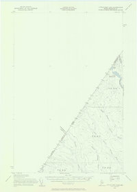 1955 Little East Lake1955 Print · USGSUpper Aroostook County’s wilderness is mapped here during the mid-fifties, showing the rugged timberlands along the Quebec border. Researchers can trace the isolated drainage of Little East Lake and the logging routes following Pocwock Stream and Fivemile Brook.3 unique versions available
 - 1955 Map of Rocky Brook, 1956 Print
 1955 Rocky Brook1956 Print · USGSThe international border in northern Aroostook County is captured here in the mid-1950s, showing a remote landscape of logging roads and rivers. Researchers can trace the winding Little Black River and locate seasonal landmarks like Rideout Pond and the Jeep Trail network.2 unique versions available
End of results
Showing maps 1-3 of 3
Top cities near T18 R13 WELS
Frequently asked questions
- What are the different types of historical maps available for T18 R13 WELS?
- What is the oldest map of T18 R13 WELS?
- Where can I purchase historical maps of T18 R13 WELS for my home or office?
- Where can I download high-res historical maps of T18 R13 WELS?
- Are there historical topographic maps available for T18 R13 WELS?
- Is there historical aerial imagery available for T18 R13 WELS?
- Where are historical maps of T18 R13 WELS sourced from?