1970s Maps of T4 R3 WELS, Maine
Explore 4 historic maps of T4 R3 WELS from the 1970s. These maps offer a rare glimpse into what life looked like during the 1970s — showing old roads, neighborhoods, homes, and landmarks that have changed or disappeared over time.
Whether you're researching your family's past, planning a metal detecting trip, or studying how T4 R3 WELS's landscape evolved across the 1970s, these high-resolution maps are a powerful tool for exploring the history of this region.
- Focus on a specific era: All maps on this page are from the 1970s, giving you a focused view of this time period.
- See what’s changed: Compare century-old streets, trails, and buildings to today's modern landscape using overlays and satellite layers.
- Research with precision: Use these maps for genealogy, historical research, land use analysis, or educational projects.
- View, download, or print: Maps are fully viewable online in high resolution, and can be downloaded or printed for your own records.
Start exploring T4 R3 WELS's history through authentic maps from the 1970s. This is your window into the past.
T4 R3 WELS, ME maps
(4)- 1975 Map of Smyrna Mills SE, 1980 Print
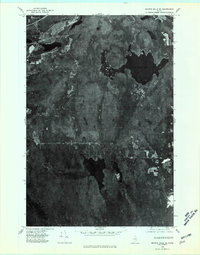 1975 Smyrna Mills SE1980 Print · USGSAroostook County's deep woods and water bodies are captured in this mid-seventies aerial survey. Researchers can trace the timber-rich terrain around Meduxnekeag Lake, Skitaccooke Lake, and the heights of Timoney Mountain.
 - 1975 Map of Smyrna Mills SW, 1980 Print
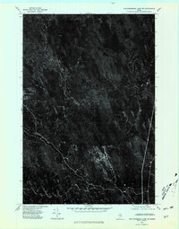
 1975 Smyrna Mills SW1980 Print · USGSAroostook County during the mid-seventies reveals the relationship between northern Maine's forest industry and its riverside settlements. Researchers can trace the development of Oakfield and Dyer Brook or locate old crossings at Red Bridge along the East Branch Mattawamkeag.
 - 1975 Map of Mattawamkeag Lake NE, 1980 Print
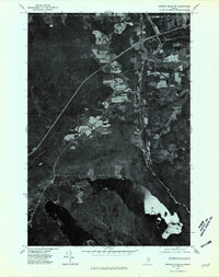
 1975 Mattawamkeag Lake NE1980 Print · USGSCovers T4 R3 WELS, including Linneus, TA R2 WELS, and other nearby areas
 - 1975 Map of Mattawamkeag Lake NW, 1980 Print
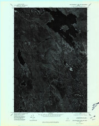 1975 Mattawamkeag Lake NW1980 Print · USGSIn the mid-1970s, the dense forests of Aroostook County were captured in this detailed aerial study. Trace the winding course of the Mattawamkeag River and find the remote waters of Mud Lake and Sly Brook.
End of results
Showing maps 1-4 of 4
Top cities near T4 R3 WELS
- Houlton historical maps
- Hodgdon historical maps
- Littleton historical maps
- Linneus historical maps
- Sherman historical maps
- Island Falls historical maps
See more
Frequently asked questions
- What are the different types of historical maps available for T4 R3 WELS?
- What is the oldest map of T4 R3 WELS?
- Where can I purchase historical maps of T4 R3 WELS for my home or office?
- Where can I download high-res historical maps of T4 R3 WELS?
- Are there historical topographic maps available for T4 R3 WELS?
- Is there historical aerial imagery available for T4 R3 WELS?
- Where are historical maps of T4 R3 WELS sourced from?