1940s Maps of Webbertown Township, Maine
Explore 4 historic maps of Webbertown Township from the 1940s. These maps offer a rare glimpse into what life looked like during the 1940s — showing old roads, neighborhoods, homes, and landmarks that have changed or disappeared over time.
Whether you're researching your family's past, planning a metal detecting trip, or studying how Webbertown Township's landscape evolved across the 1940s, these high-resolution maps are a powerful tool for exploring the history of this region.
- Focus on a specific era: All maps on this page are from the 1940s, giving you a focused view of this time period.
- See what’s changed: Compare century-old streets, trails, and buildings to today's modern landscape using overlays and satellite layers.
- Research with precision: Use these maps for genealogy, historical research, land use analysis, or educational projects.
- View, download, or print: Maps are fully viewable online in high resolution, and can be downloaded or printed for your own records.
Start exploring Webbertown Township's history through authentic maps from the 1940s. This is your window into the past.
Webbertown Township, ME maps
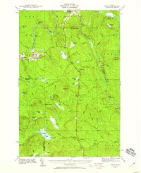
(4)- 1940 Map of Island Falls, 1957 Print
 1940 Island Falls1957 Print · USGSThe river-and-rail landscape of southern Aroostook County is captured here in the years before the war. Researchers can trace the exact locations of numerous rural schoolhouses like Allsbury Sch and Myrick Sch or locate the Bangor and Aroostook RR through Island Falls.4 unique versions available
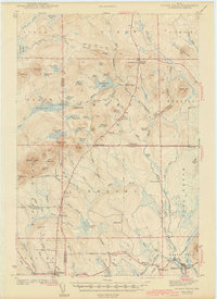
 - 1940 Map of Oxbow, 1960 Print
 1940 Oxbow1960 Print · USGSAroostook County was a remote timber and river frontier when this survey was conducted in the early 1940s. Genealogists and historians can trace old homesteads around Oxbow, locate the Oxbow East End School, and follow the Loghauler Road through the woods.
 - 1942 Map of Island Falls
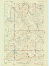
 1942 Island Falls1942 Print · USGSNorthern Maine's timber and rail frontier comes into focus in the early 1940s as the Bangor and Aroostook RR connects the woods to the world. Genealogists and historians can trace numerous rural schoolhouses like Rockabema Sch and the storied Patten Academy among the hills of Mount Chase.
 - 1942 Map of Oxbow
 1942 Oxbow1942 Print · USGSNorthern Maine's timber and rail landscape is captured here during the early 1940s, centered on the river-bound community of Oxbow. Genealogists can locate Willard Cem, East End Sch, and remote logging outposts like Camp Violette.2 unique versions available
End of results
Showing maps 1-4 of 4
Top cities near Webbertown Township
- Linneus historical maps
- Patten historical maps
- Island Falls historical maps
- Oakfield historical maps
- New Limerick historical maps
- Smyrna historical maps
See more
Frequently asked questions
- What are the different types of historical maps available for Webbertown Township?
- What is the oldest map of Webbertown Township?
- Where can I purchase historical maps of Webbertown Township for my home or office?
- Where can I download high-res historical maps of Webbertown Township?
- Are there historical topographic maps available for Webbertown Township?
- Is there historical aerial imagery available for Webbertown Township?
- Where are historical maps of Webbertown Township sourced from?