1980s Maps of Winterville Plantation, Maine
Explore 4 historic maps of Winterville Plantation from the 1980s. These maps offer a rare glimpse into what life looked like during the 1980s — showing old roads, neighborhoods, homes, and landmarks that have changed or disappeared over time.
Whether you're researching your family's past, planning a metal detecting trip, or studying how Winterville Plantation's landscape evolved across the 1980s, these high-resolution maps are a powerful tool for exploring the history of this region.
- Focus on a specific era: All maps on this page are from the 1980s, giving you a focused view of this time period.
- See what’s changed: Compare century-old streets, trails, and buildings to today's modern landscape using overlays and satellite layers.
- Research with precision: Use these maps for genealogy, historical research, land use analysis, or educational projects.
- View, download, or print: Maps are fully viewable online in high resolution, and can be downloaded or printed for your own records.
Start exploring Winterville Plantation's history through authentic maps from the 1980s. This is your window into the past.
Winterville Plantation, ME maps
(4)- 1985 Map of Eagle Lake, 1986 Print
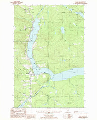 1985 Eagle Lake1986 Print · USGSAroostook County's lake country is captured in the 1980s, showing the vital water connection between Eagle Lake and the Fish River. Researchers can trace local landmarks like the Plaisted village center, the Winterville Plantation boundary, and the Thoroughfare waterway.
 - 1985 Map of Island Pond, 1986 Print
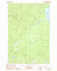 1985 Island Pond1986 Print · USGSThe North Maine Woods are captured in the mid-1980s, showing a landscape of timber tracts and river systems. You can trace logging history through a network of Private Roads and Gravel Pits near St Froid Lake and Island Pond.
 - 1985 Map of Wallagrass Lakes, 1986 Print
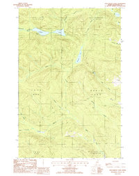 1985 Wallagrass Lakes1986 Print · USGSNorthern Maine's lake country is captured in the mid-1980s when timber and water dominated the landscape of the northern townships. Researchers can trace the drainage patterns of Wallagrass Lakes and identify early land divisions in St John Plantation and Winterville Plantation.
 - 1985 Map of Winterville, 1986 Print
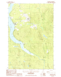 1985 Winterville1986 Print · USGSAroostook County's North Woods are mapped here in the mid-1980s, centered on the railroad corridor and timberlands of Winterville Plantation. Researchers can trace the Canadian Pacific line through Quimby and locate old settlements like McNally and Nixon.
End of results
Showing maps 1-4 of 4
Top cities near Winterville Plantation
- Ashland historical maps
- Eagle Lake historical maps
- Square Lake historical maps
- Wallagrass historical maps
- Saint Francis historical maps
- Portage Lake historical maps
See more
Top neighborhoods of Winterville Plantation
Frequently asked questions
- What are the different types of historical maps available for Winterville Plantation?
- What is the oldest map of Winterville Plantation?
- Where can I purchase historical maps of Winterville Plantation for my home or office?
- Where can I download high-res historical maps of Winterville Plantation?
- Are there historical topographic maps available for Winterville Plantation?
- Is there historical aerial imagery available for Winterville Plantation?
- Where are historical maps of Winterville Plantation sourced from?