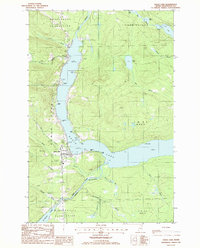
1985 Map of Eagle Lake
USGS Topo · Published 1986About this map
Eagle Lake serves as the central focal point of this northern Aroostook County landscape, where the waters of the Fish River connect a chain of glacial lakes. In the mid-1980s, the community of Eagle Lake and the nearby village of Plaisted represent the primary settlements along the western shore, anchored by a Po and local services. The map details a transition from organized townships like Wallagrass Plantation and Winterville Plantation to the more interior forest tracts of New Canada and T 16 R 6 Wels. Numerous family-named points such as Dubay Point and Browns Point line the lakefront, while the interior is etched by a network of drainage brooks including Gilmore Brook and Devoe Brook. The presence of several Gravel Pits and a Substation suggests the infrastructure supporting this timber and recreation-oriented region near the southern reach of St Froid Lake.
Find a feature on this map
43 named features on this map. Tap any name to fly to it.
Don’t see what you’re looking for? This feature index may not catch every label — zoom into the map to look around manually.
Map Details
Editions of this 1985 Eagle Lake Map
This is the sole edition of this map. No revisions or reprints were ever made.
Other maps of this area

1927 · Square Lake
USGS Topo · 1:48,000

1928 · Eagle Lake
USGS Topo · 1:48,000

1928 · Winterville
USGS Topo · 1:48,000

1929 · Portage
USGS Topo · 1:62,500

1931 · Square Lake
USGS Topo · 1:62,500

1931 · Eagle Lake
USGS Topo · 1:62,500

1931 · Portage
USGS Topo · 1:62,500

1931 · Winterville
USGS Topo · 1:62,500

1953 · Square Lake
USGS Topo · 1:62,500

1953 · Portage
USGS Topo · 1:62,500