2020s Maps of Jay, Maine
Explore 6 historic maps of Jay from the 2020s. These maps offer a rare glimpse into what life looked like during the 2020s — showing old roads, neighborhoods, homes, and landmarks that have changed or disappeared over time.
Whether you're researching your family's past, planning a metal detecting trip, or studying how Jay's landscape evolved across the 2020s, these high-resolution maps are a powerful tool for exploring the history of this region.
- Focus on a specific era: All maps on this page are from the 2020s, giving you a focused view of this time period.
- See what’s changed: Compare century-old streets, trails, and buildings to today's modern landscape using overlays and satellite layers.
- Research with precision: Use these maps for genealogy, historical research, land use analysis, or educational projects.
- View, download, or print: Maps are fully viewable online in high resolution, and can be downloaded or printed for your own records.
Start exploring Jay's history through authentic maps from the 2020s. This is your window into the past.
Jay, ME maps
(6)- 2021 Map of Wilton, 2021 Print
 2021 Wilton2021 Print · USGSCovers Jay, including Farmington, Wilton, and other nearby areas
 - 2021 Map of East Dixfield, 2021 Print
 2021 East Dixfield2021 Print · USGSCovers Jay, including Wilton, Dixfield, and other nearby areas
 - 2021 Map of Livermore Falls, 2021 Print
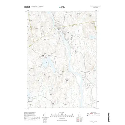 2021 Livermore Falls2021 Print · USGSCovers Jay, including Livermore Falls, Livermore, and other nearby areas
 - 2024 Map of Livermore Falls, 2024 Print
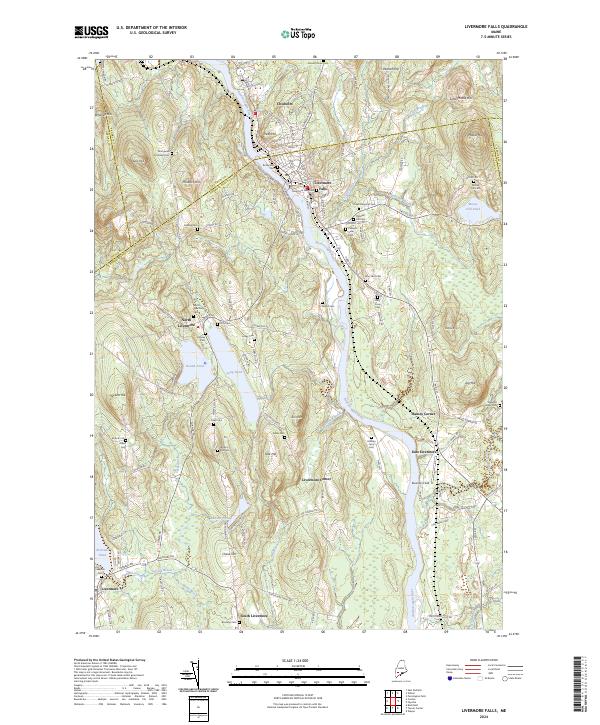 2024 Livermore Falls2024 Print · USGSThe Androscoggin River valley of central Maine is captured here in modern detail, showing the enduring layout of riverfront towns and upland farmsteads. Family historians can locate dozens of burial sites like Treat Memorial Cem and Lakeside Cem alongside landmarks like Bowman Field.
 - 2024 Map of Wilton, 2024 Print
 2024 Wilton2024 Print · USGSFranklin County's southern corridor comes into focus in the early 2020s, showing the enduring village centers of Wilton, East Wilton, and Jay. Researchers can trace old family burial grounds like North Jay Cem or follow the course of the Androscoggin River.
 - 2024 Map of East Dixfield, 2024 Print
 2024 East Dixfield2024 Print · USGSFranklin and Oxford Counties are captured in this recent survey of the Maine interior, showing a landscape of persistent rural character. Genealogists can trace family connections through numerous sites like Severy Hill Cem, East Dixfield Cem, and the heights of Colonel Holman Mtn.
End of results
Showing maps 1-6 of 6
Top cities near Jay
- Farmington historical maps
- Winthrop historical maps
- Turner historical maps
- Paris historical maps
- Wilton historical maps
- Livermore Falls historical maps
See more
Top neighborhoods of Jay
- North Jay historical maps
- Chisholm historical maps
- Stones Corner historical maps
- Riley historical maps
- Beans Corner historical maps
Frequently asked questions
- What are the different types of historical maps available for Jay?
- What is the oldest map of Jay?
- Where can I purchase historical maps of Jay for my home or office?
- Where can I download high-res historical maps of Jay?
- Are there historical topographic maps available for Jay?
- Is there historical aerial imagery available for Jay?
- Where are historical maps of Jay sourced from?